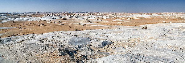
ഫറഫ്ര, ഈജിപ്ത്
Farafra | |
|---|---|
 | |
| Coordinates: 27°03′30″N 27°58′12″E / 27.05833°N 27.97000°E | |
| Country | |
| Governorate | New Valley Governorate |
| സമയമേഖല | UTC+2 (EST) |
പടിഞ്ഞാറൻ ഈജിപ്തിലെ രണ്ടാമത്തെ വലിപ്പമുള്ളതും ചെറിയ ജനസംഖ്യയുള്ളതും 980 ചതുരശ്രകിലോമീറ്ററുള്ളതും (380 ച. മൈ), 27.06 ° വടക്കും രേഖാംശം 27.97 ° കിഴക്കും അക്ഷാംശത്തിന് സമീപം സ്ഥിതിചെയ്യുന്ന ഒരു ജിയോളജിക്കൽ ഡിപ്രഷൻ ആണ് ഫറഫ്ര ഡിപ്രഷൻ. ഈജിപ്തിലെ ഏറ്റവും വലിയ പടിഞ്ഞാറൻ മരുഭൂമികളിൽ ഒന്നായ ഇത് ദഖ്ല, ബഹരിയ എന്നീ മരീചികയുടെ മധ്യഭാഗങ്ങൾക്കിടയിലാണ് സ്ഥിതിചെയ്യുന്നത്.
കാലാവസ്ഥ
Köppen-Geiger climate classification system classifies its climate as hot desert (BWh).
| Farafra, Egypt പ്രദേശത്തെ കാലാവസ്ഥ | |||||||||||||
|---|---|---|---|---|---|---|---|---|---|---|---|---|---|
| മാസം | ജനു | ഫെബ്രു | മാർ | ഏപ്രി | മേയ് | ജൂൺ | ജൂലൈ | ഓഗ | സെപ് | ഒക് | നവം | ഡിസം | വർഷം |
| റെക്കോർഡ് കൂടിയ °C (°F) | 31.8 (89.2) |
37.2 (99) |
41.5 (106.7) |
46.4 (115.5) |
47.5 (117.5) |
47.8 (118) |
44.7 (112.5) |
45.1 (113.2) |
43.4 (110.1) |
42.6 (108.7) |
37.8 (100) |
31.2 (88.2) |
47.8 (118) |
| ശരാശരി കൂടിയ °C (°F) | 20.0 (68) |
22.4 (72.3) |
26.2 (79.2) |
31.6 (88.9) |
35.4 (95.7) |
37.8 (100) |
37.8 (100) |
37.3 (99.1) |
35.1 (95.2) |
31.2 (88.2) |
25.5 (77.9) |
21.1 (70) |
30.1 (86.2) |
| പ്രതിദിന മാധ്യം °C (°F) | 12.0 (53.6) |
14.0 (57.2) |
17.8 (64) |
22.8 (73) |
27.0 (80.6) |
29.4 (84.9) |
30.3 (86.5) |
29.9 (85.8) |
27.2 (81) |
23.1 (73.6) |
17.6 (63.7) |
13.6 (56.5) |
22.1 (71.8) |
| ശരാശരി താഴ്ന്ന °C (°F) | 4.1 (39.4) |
6.0 (42.8) |
9.2 (48.6) |
13.8 (56.8) |
17.9 (64.2) |
20.6 (69.1) |
21.9 (71.4) |
21.5 (70.7) |
19.5 (67.1) |
15.6 (60.1) |
10.1 (50.2) |
5.6 (42.1) |
13.8 (56.8) |
| താഴ്ന്ന റെക്കോർഡ് °C (°F) | −3.3 (26.1) |
−2.2 (28) |
−0.2 (31.6) |
2.9 (37.2) |
7.6 (45.7) |
13.9 (57) |
16.9 (62.4) |
16.8 (62.2) |
13.5 (56.3) |
7.3 (45.1) |
0.6 (33.1) |
−2.1 (28.2) |
−3.3 (26.1) |
| മഴ/മഞ്ഞ് mm (inches) | 1 (0.04) |
0 (0) |
0 (0) |
0 (0) |
0 (0) |
0 (0) |
0 (0) |
0 (0) |
0 (0) |
0 (0) |
1 (0.04) |
0 (0) |
2 (0.08) |
| ശരാ. മഴ/മഞ്ഞു ദിവസങ്ങൾ (≥ 1.0 mm) | 0.1 | 0.1 | 0 | 0.1 | 0 | 0 | 0 | 0 | 0 | 0 | 0 | 0 | 0.3 |
| % ആർദ്രത | 51 | 43 | 38 | 29 | 26 | 26 | 28 | 31 | 36 | 42 | 55 | 53 | 38.2 |
| Source #1: NOAA[1] | |||||||||||||
| ഉറവിടം#2: Climate Charts[2] | |||||||||||||
ചിത്രശാല
Farafra Desert
അവലംബം
- ↑ "Farafra Climate Normals 1961–1990". National Oceanic and Atmospheric Administration. Retrieved October 25, 2015.
- ↑ "Farafra, Egypt: Climate, Global Warming, and Daylight Charts and Data". Climate Charts. Archived from the original on 17 August 2013. Retrieved 17 July 2013.
ബിബ്ലിയോഗ്രാഫി
- Frank Bliss: 'Oasenleben. Die ägyptischen Oasen Bahriya und Farafra in Vergangenheit und Gegenwart'. Die ägyptischen Oasen Band 2. Bonn 2006.
- Frank Bliss: 'Artisanat et artisanat d’art dans les oasis du désert occidental égyptien'. "Veröffentlichungen des Frobenius-Instituts". Köln 1998.
- Beadnell, Hugh J. L. The Farafra Oasis: Its Topography and Geology. Geological Survey Report... Part 3 of Geological Survey Report, Geological Survey Report]. Egypt. Maṣlaḥat al-Misāḥah. 1901.
- Fakhry, Ahmed. 1974. Bahriyah and Farafra. Reissue of the Classic History and Description. Illustrated, reprint. Publisher: American Univ. in Cairo Press, 1974. ISBN 9774247329, 9789774247323. 189 pages.
ബാഹ്യ ലിങ്കുകൾ
White Desert, Egypt എന്ന വിഷയവുമായി ബന്ധപ്പെട്ട ചിത്രങ്ങൾ വിക്കിമീഡിയ കോമൺസിലുണ്ട്.
- Travel guide Archived 2011-02-01 at the Wayback Machine
- (in German) Farafra oasis on Wikivoyage
- Images from Farafra and White Desert Archived 2011-02-01 at the Wayback Machine


