ഫലകം:Infobox mine
Blank infobox
| [[File:{image}|{width}]] {caption} | |
| Location | |
|---|---|
| Location | {place} |
| {subdivision_type} | {state/province} |
| Country | {country} |
| Coordinates | Use {Coord} |
| Production | |
| Products | {products} |
| Production | {amount} |
| Financial year | {financial year} |
| Type | {type} |
| Greatest depth | {greatest depth} |
| History | |
| Opened | {opening year} |
| Active | {active years} |
| Closed | {closing year} |
| Owner | |
| Company | {owner} |
| Website | {official website} |
| Year of acquisition | {acquisition year} |
| {module} | |
{Infobox mine
| name               =
| image              =
| width              =
| caption            =
| pushpin_map        =
| pushpin_mapsize    =
| pushpin_map_alt    =
| pushpin_map_caption=
| pushpin_image      =
| pushpin_label      =
| pushpin_label_position =
| coordinates        = <!-- {Coord|latitude|N/S|longitude|E/W|display=inline,title} -->
| place              =
| subdivision_type   =
| state/province     =
| country            =
| products           =
| amount             = <!--include units-->
| financial year     =
| type               =
| greatest depth     =
| opening year       = <!-- {Start date|YYYY} -->
| active years       = <!-- use only if inactive for a period of time-->
| closing year       = <!-- {End date|YYYY} -->
| owner              =
| official website   = <!-- {URL|example.com} -->
| acquisition year   =
| module             = <!-- or 'embedded' or 'nrhp' -->
}
Parameters
Name and image
- name = The common name of the mine.
- image = An image of the mine (without the prefix "Image:").
- width = Image width e.g. 200px
- caption = Caption for the image.
Location map
- pushpin_map = Name of a location map definition (not a File: or Image: name) which can use with Template:Location map (i.e. "Colorado" would generate {Location map|Colorado} which uses map definitions from Template:Location map Colorado).
- pushpin_mapsize = Optional. The width to display the pushpin map, in pixels. Just the number, no "px". If the parameter is omitted or value left empty, defaults to 220.
- pushpin_map_alt = Optional. Alt text for the pushpin map.
- pushpin_map_caption = Optional. Caption to display below the pushpin map.
- pushpin_image = Optional. File name of a different image using same map coordinates.
- pushpin_label = Optional. The label to place next to the pushpin coordinate marker. Defaults to the value of the name parameter.
- pushpin_label_position = Optional. The position of the label on the pushpin map relative to the pushpin coordinate marker. Valid options are left, right, top, bottom, and none. Defaults to right.
Coordinates
- coordinates = Geographic coordinates, using the {Coord} template (with
|display=inline,title). Unless a value fortype:is specified,type:landmarkis automatically added; unless a value forregion:is specified, the template attempts to convert|country=and|state/province=into a valid region code which is automatically added. See {Coord} for more information on how to use it.
Location
- place =
- subdivision_type = state/province (affects label for the next entry)
- state/province =
- country =
- the coordinates are displayed below the country
Production
- products = what the mine produces/produced: e.g. silver, zinc, bauxite. May list more than one
- amount = mine production (with unit, e.g. tons, troy ounces, etc.)
- financial year = year of above the production figure, or "lifetime"
- type = e.g. open-pit, underground, etc.
- greatest depth =
History
- opening year = Year mine opened. Use {Start date}.
- active years = Use if mine opened and closed more than once. Such as 1990-1995, 1997-2002; use {Start date} for the first one only.
- closing year = Year mine closed. Use {End date}.
Owner
- owner =
- official website = use {URL}
- acquisition year =
Embedding other templates
The module=, embedded=, or nrhp= parameters can be used for embedding other templates into this infobox (see Wikipedia:Infobox modules):
{Infobox mine
| name =
...
| module = <!-- or 'embedded' or 'nrhp' -->
  {Infobox ABC
  | embed = yes <!-- or child=yes or subbox=yes-->
  ...
  }
}
Example
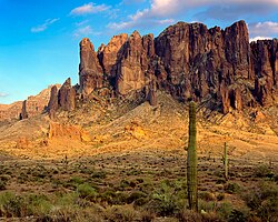 Supersition Mountains | |
| Location | |
|---|---|
 Lost Dutchman's Mine | |
| Location | Superstition Mountains |
| State | Arizona |
| Country | United States |
| Coordinates | 33°25′34″N 111°07′22″W / 33.42598°N 111.12266°W |
| Production | |
| Products | Gold |
| Production | 50,000 troy ounces |
| Financial year | Lifetime |
| Type | Underground |
| History | |
| Opened | 1875 |
| Closed | 1883 |
| Owner | |
| Company | Jacob Waitz |
| Website | en |
{Infobox mine
| name               = Lost Dutchman's Mine
| image              = SUPERSTITIONS AZ15.jpg
| width              = 250px
| caption            = Supersition Mountains
| pushpin_map        = Arizona
| pushpin_mapsize    = 200px
| pushpin_map_alt    =
| pushpin_map_caption=
| pushpin_image      =
| pushpin_label      =
| pushpin_label_position =
| coordinates        = {coord|33.42598|N|111.12266|W|display=inline,title}
| place              = [[Superstition Mountains]]
| subdivision_type   = State
| state/province     = [[Arizona]]
| country            = United States
| products           = Gold
| amount             = 50,000 troy ounces
| financial year     = Lifetime
| type               = Underground
| greatest depth     =
| opening year       = {Start date|1875}
| active years       = <!-- use only if inactive for a period of time-->
| closing year       = {End date|1883}
| owner              = Jacob Waitz
| official website   = {URL|http://en.wikipedia.org/wiki/Lost_Dutchman%27s_Gold_Mine}
| acquisition year   =
| stock_exchange     =
| stock_code         =
| module             =
}
Microformat
The HTML markup produced by this template includes an hCard microformat, which makes the place-name and location parsable by computers, either acting automatically to catalogue articles across Wikipedia, or via a browser tool operated by a person, to (for example) add the subject to an address book. Within the hCard is a Geo microformat, which additionally makes the coordinates (latitude & longitude) parsable, so that they can be, say, looked up on a map, or downloaded to a GPS unit. For more information about the use of microformats on Wikipedia, please see the microformat project.
Sub-templates
If the place or venue has "established", "founded", "opened" or similar dates, use {start date} for the earliest of those dates unless the date is before 1583 CE.
If it has a URL, use {URL}.
Please do not remove instances of these sub-templates.
Classes
hCard uses HTML classes including:
- adr
- agent
- category
- county-name
- extended-address
- fn
- label
- locality
- nickname
- note
- org
- region
- street-address
- uid
- url
- vcard
Geo is produced by calling {coord}, and uses HTML classes:
- geo
- latitude
- longitude
Please do not rename or remove these classes nor collapse nested elements which use them.
Precision
When giving coordinates, please use an appropriate level of precision. Do not use {coord}'s |name= parameter.