Amapá
State of Amapá | |
|---|---|
State | |
  | |
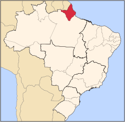 Location of State of Amapá in Brazil | |
| Country | |
| Capital and Largest City | Macapá |
| Kerajaan | |
| • Governor | Camilo Góes Capiberibe |
| • Vice Governor | Dora Nascimento de Souza |
| Luas | |
| • Jumlah | 142,814.585 km2 (55,141.020 batu persegi) |
| Ranking kawasan | 18th |
| Penduduk (2010 census)[1] | |
| • Jumlah | 668,689 |
| • Kedudukan | 26th |
| • Kepadatan | 4.7/km2 (12/batu persegi) |
| • Kedudukan kepadatan | 24th |
| Demonym(s) | Amapaense |
| GDP | |
| • Year | 2006 estimate |
| • Total | R$ 5,260,000,000 (25th) |
| • Per capita | R$ 8,543 (14th) |
| HDI | |
| • Year | 2005 |
| • Category | 0.780 – medium (12th) |
| Zon waktu | UTC-3 (BRT) |
| Postal Code | 68900-000 to 68999-000 |
| Kod ISO 3166 | BR-AP |
Amapá merupakan sebuah wilayah di Brazil. Penduduknya berjumlah 477,032 orang (2002).
Lihat juga
- Brazil
- Calçoene - Amapá town, site of pre-colonial observatory
Rujukan
Pautan luar
| Ketahui lebih lanjut tentang Amapá di Wikipedia: | |
| Takrifan dari Wikikamus | |
| Imej dan media dari Commons | |
| Sumber pembelajaran dari Wikiversity | |
| Berita dari Wikiberita | |
| Petikan dari Wikipetikan | |
| Teks sumber dari Wikisumber | |
| Buku teks dari Wikibuku | |
- (Portugis) Official Website
| Wilayah Brazil | |
|---|---|
| Acre | Alagoas | Amapá | Amazonas | Bahia | Ceará | Espírito Santo | Goiás | Maranhão | Mato Grosso | Mato Grosso do Sul | Minas Gerais | Pará | Paraíba | Paraná | Pernambuco | Piauí | Rio de Janeiro | Rio Grande do Norte | Rio Grande do Sul | Rondônia | Roraima | Santa Catarina | São Paulo | Sergipe | Tocantins | |
| Daerah Persekutuan: Daerah Persekutuan Brazil | |