ढाँचा:Infobox river
| {name} {name_other} | |
|---|---|
| [[File:{image}|{image_size}|alt={image_alt}|upright=1]] {image_caption} | |
| [[File:{map}|{map_size}|alt={map_alt}]] {map_caption} | |
| नामाकरण | {etymology} |
| उपनाम(हरू) | {nickname} |
| स्थानीय नाम | [{name_native}] Error: {स्थानीय नाम}: unrecognized language tag: {name_native_lang} (help) (भाषा?) |
| स्थान | |
| {subdivision_type1} | {subdivision_name1} |
| {subdivision_type2} | {subdivision_name2} |
| {subdivision_type3} | {subdivision_name3} |
| {subdivision_type4} | {subdivision_name4} |
| {subdivision_type5} | {subdivision_name5} |
| भौतिक विषेशताहरू | |
| स्रोत | {source1} |
| • स्थान | {source1_location} |
| • भौगोलिक निर्देशाङ्क | {source1_coordinates}{source1_coord_ref} |
| • उन्नतांस | {source1_elevation} |
| पाँचौ स्रोत | {source5} |
| • स्थान | {source5_location} |
| • भौगोलिक निर्देशाङ्क | {source5_coordinates}{source5_coord_ref} |
| • उन्नतांस | {source5_elevation} |
| स्रोतको सङ्गमस्थल | {source_confluence} |
| • स्थान | {source_confluence_location} |
| • भौगोलिक निर्देशाङ्क | {source_confluence_coordinates} |
| • उन्नतांस | {source_confluence_elevation} |
| मुख | {mouth} |
• स्थान | {mouth_location} |
• भौगोलिक निर्देशाङ्क | {mouth_coordinates}{mouth_coord_ref} |
• उन्नतांस | {mouth_elevation} |
| लम्बाइ | {length} |
| जलाधारकाे क्षेत्रफल | {basin_size} |
| चौडाइ | |
| • न्युनतम | {width_min} |
| • औसत | {width_avg} |
| • अधिकतम | {width_max} |
| गहिराइ | |
| • न्युनतम | {depth_min} |
| • औसत | {depth_avg} |
| • अधिकतम | {depth_max} |
| निकास | {discharge1} |
| • स्थान | {discharge1_location} |
| • औसत | {discharge1_avg} |
| • न्युनतम | {discharge1_min} |
| • अधिकतम | {discharge1_max} |
| निकास | {discharge5} |
| • स्थान | {discharge5_location} |
| • औसत | {discharge5_avg} |
| • न्युनतम | {discharge5_min} |
| • अधिकतम | {discharge5_max} |
| जलाधारका विशेषताहरू | |
| Progression | {progression} |
| नदी प्रणाली | {river_system} |
| स्थल चिन्हहरू | {basin_landmarks} |
| सहरहरू | {city} |
| जनसङ्ख्या | {basin_population} |
| सहायक नदीहरू | |
| • बायाँ | {tributaries_left} |
| • दायाँ | {tributaries_right} |
| नदीका हिस्साहरू | {waterbodies} |
| झरना(हरू) | {waterfalls} |
| पुलहरू | {bridges} |
| Inland ports | {ports} |
| {custom_label} | {custom_data} |
| {extra} | |
Usage
{Infobox river
| name               =
| name_native        =
| name_native_lang   =
| name_other         =
| name_etymology     =
| nickname           =
<!---------------------- IMAGE-->
| image              =
| image_size         =
| image_caption      =
| image_alt          =
<!---------------------- MAPS -->
| map                =
| map_size           =
| map_caption        =
| map_alt            =
| pushpin_map        =
| pushpin_map_size   =
| pushpin_map_caption=
| pushpin_map_alt    =
<!---------------------- LOCATION -->
| subdivision_type1  =
| subdivision_name1  =
| subdivision_type2  =
| subdivision_name2  =
| subdivision_type3  =
| subdivision_name3  =
| subdivision_type4  =
| subdivision_name4  =
| subdivision_type5  =
| subdivision_name5  =
<!---------------------- PHYSICAL CHARACTERISTICS -->
| length             =
| width_min          =
| width_avg          =
| width_max          =
| depth_min          =
| depth_avg          =
| depth_max          =
| discharge1_location=
| discharge1_min     =
| discharge1_avg     =
| discharge1_max     =
<!---------------------- BASIN FEATURES -->
| source1            =
| source1_location   =
| source1_coordinates= <!-- {Coord|...} -->
| source1_elevation  =
| mouth              =
| mouth_location     =
| mouth_coordinates  = <!-- {Coord|...|display=inline,title} -->
| mouth_elevation    =
| progression        =
| river_system       =
| basin_size         =
| basin_landmarks    =
| basin_population   =
| tributaries_left   =
| tributaries_right  =
| waterbodies        =
| waterfalls         =
| bridges            =
| ports              =
| custom_label       =
| custom_data        =
| extra              =
}
Parameter names and descriptions
| Parameter name | Description |
|---|---|
| name | The common name of the river. |
| name_native | The native/local name of the river. |
| name_native_lang | ISO 639-1 or ISO 639-2 language code of the language used in name_native. Used for accessibility.
|
| name_other | Other name(s) of the river. Use commas to enter multiple. |
| name_etymology | Person, event or other entity the body is named after |
| image | Image filename without the File: or Image: prefix.
|
| image_size | Width of the image in pixels (i.e. 200px). Common sizes are usually around 280px to 300px.
|
| image_caption | Caption for the main image. |
| image_alt | Alt text for the main image. |
| map | Map image filename without the File: or Image: prefix.
|
| map_size | Width of the image in pixels (i.e. 200px). Common sizes are usually around 280px to 300px.
|
| map_caption | Caption for the map image. |
| map_alt | Alt text for the map image. |
| pushpin_map | The name of a location map to be used with {location map}, with the pin placed at the location specified by the mouth_coordinates parameter, or the value from wikidata if no mouth coordinates are provided. Manually add parameter pushpin_map_relief = 0 to disable the use of a relief location map.
|
| pushpin_map_size | The width of the location map in pixels as a raw number, without any px suffix
|
| pushpin_map_caption | Caption for the location map |
| pushpin_map_alt | Alt text for the location map image. |
| subdivision_type1 | Primary political region(s), typically Country or Countries.
|
| subdivision_name1 | Used with above. The country/ies in which the river flows in/through. Use commas for multiple. |
| subdivision_type2 | Secondary political region(s). States, Provinces, Districts, or Regions, in which the river flows through.
|
| subdivision_name2 | Used with above. The secondary political region(s) in which the river flows through. Use commas for multiple. |
| subdivision_type3 | Tertiary political region(s), such as the Cities along the river.
|
| subdivision_name3 | Used with above. The tertiary political region(s) through which the river flows. Use commas for multiple. |
| subdivision_type4 | Other types of political subdivisions. |
| subdivision_name4 | Used with above. Other political subdivisions through which the river flows. Use commas for multiple. |
| subdivision_type5 | Other types of political subdivisions. |
| subdivision_name5 | Used with above. Other political subdivisions through which the river flows. Use commas for multiple. |
| length | The total length of the river's main stem. Consider using {Convert|1234|km|mi|abbr=on}
|
| width_min | Minimum width between banks of the river. Rarely used as it is often difficult to determine the exact source of the river. Consider using {Convert|1234|m|ft|abbr=on}
|
| width_avg | Average width of the river. Consider using {Convert|1234|m|ft|abbr=on}
|
| width_max | Maximum width of the river before the mouth. Consider using {Convert|1234|m|ft|abbr=on}
|
| depth_min | Minimum depth of the river. Rarely used as it is often difficult to determine the exact source of the river. Consider using {Convert|1234|m|ft|abbr=on}
|
| depth_avg | Average depth of the river. Consider using {Convert|1234|m|ft|abbr=on}
|
| depth_max | Maximum depth of the river before the mouth. Consider using {Convert|1234|m|ft|abbr=on}
|
| discharge1_location | Location or gauge/sensor name at which the below details are recorded. Commonly at the River mouth.You may add up to discharge5.
|
| discharge1_min | Minimum discharge rate. Rarely used. Consider using {Convert|1234|m3/s|ft3/s|abbr=on}
|
| discharge1_avg | Average discharge rate. Consider using {Convert|1234|m3/s|ft3/s|abbr=on}
|
| discharge1_max | Maximum discharge rate before flooding occurs in the surrounding areas. Consider using {Convert|1234|m3/s|ft3/s|abbr=on}
|
| source1 | Landform or waterbody of the primary source. You may add up to source5. For a source that is a confluence, you may add as:Confluence of [[River-A]] and [[River-B]].
|
| source1_location | Political details of the source location, such as Province, District, State, etc. |
| source1_coordinates | Coordinates of the main source, using the {coord} template. |
| source1_elevation | Elevation at the main source of water |
| mouth | Landform or waterbody of the river mouth. |
| mouth_location | Political details of the mouth location, such as Province, District, State, etc. |
| mouth_coordinates | Coordinates of the river mouth, using the {coord} template. Use |display=inline,title if possible.
|
| mouth_elevation | Elevation at the river mouth. |
| progression | Progression of rivers. |
| river system | Name of the river system. |
| basin_landmarks | Popular landmarks along the river. Use commas for multiple. |
| basin_population | Population within the river basin. |
| basin_size | Size of the river's drainage basin. Consider using {Convert|1234|km2|mi2|abbr=on}
|
| tributaries_left | Tributaries located on the left bank of the river flowing towards the mouth. List in order from source to mouth. |
| tributaries_right | Tributaries located on the right bank of the river flowing towards the mouth. List in order from source to mouth. |
| waterbodies | Water bodies located along the river (such as lakes, reservoirs, etc). List in order from source to mouth. |
| waterfalls | Waterfalls along the river. List in order from source to mouth. |
| bridges | Bridges along the river. List in order from source to mouth. |
| ports | Inland ports along the river. List in order from source to mouth. |
| custom_label | Use this to enter a custom label (such as bridges). To be used with the field below.
|
| custom_data | Custom data parameter. See above. |
| extra | Use this parameter to add content to the very bottom of the infobox. Useful for adding maps, charts, and so on. |
| Amazon River (dummy data) Apurímac, Ene, Tambo, Ucayali, Amazonas, Solimões | |
|---|---|
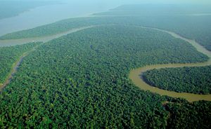 Aerial view of the Amazon River | |
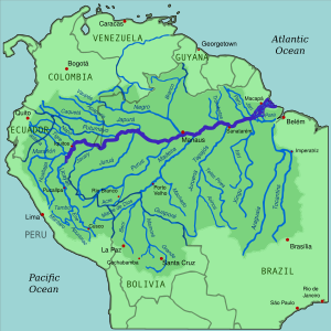 Map of the Amazon basin | |
| Lua error in मोड्युल:Location_map at line 555: खुलाइएको स्थान नक्सा परिभाषा भेटिएन: "Module:Location map/data/Brazil" उपलब्ध छैन्. | |
| नामाकरण | Named after the Amazon Rainforest |
| स्थानीय नाम | {स्थानीय नाम} त्रुटि: प्यारामिटर {1} हिसाबमा एक आइइटिएफ भाषा चिह्न आवश्यक (सहायता) |
| स्थान | |
| Countries | Brazil, Colombia, Peru, Ecuador |
| States | Loreto (Peru); Amazonas (Columbia); North Region (Brazil) |
| Cities | Iquitos (Peru); Leticia (Colombia); Tabatinga (Brazil); Tefé (Brazil); Itacoatiara (Brazil); Parintins (Brazil); Óbidos (Brazil); Santarém (Brazil); Almeirim (Brazil); Macapá (Brazil) |
| भौतिक विषेशताहरू | |
| स्रोत | Nevado Mismi, Peru |
| • स्थान | Arequipa Region |
| • भौगोलिक निर्देशाङ्क | १५°३१′०५″द ७१°४५′५५″प / 15.51806°S 71.76528°W |
| • उन्नतांस | ५,१७० मी (१६,९६० फिट) |
| मुख | Atlantic Ocean |
• स्थान | State of Amapá, State of Pará |
• भौगोलिक निर्देशाङ्क | ००°४२′२८″द ५०°०५′२२″प / 0.70778°S 50.08944°W |
• उन्नतांस | ० मी (० फिट) |
| लम्बाइ | ६,९९२ किमी (४,३४५ माइल) |
| जलाधारकाे क्षेत्रफल | ७०,५०,००० किमी२ (२७,२०,००० वर्ग माइल) |
| चौडाइ | |
| • न्युनतम | ४ किमी (२.५ माइल) |
| • औसत | ६ किमी (३.७ माइल) |
| • अधिकतम | ८ किमी (५.० माइल) |
| गहिराइ | |
| • न्युनतम | ३ मी (९.८ फिट) |
| • औसत | १५ मी (४९ फिट) |
| • अधिकतम | ३० मी (९८ फिट) |
| निकास | |
| • स्थान | Santarém, Pará |
| • औसत | २,०९,००० मी3/सेक (७४,००,००० घन फिट/सेक) |
| • न्युनतम | १,०९,००० मी3/सेक (३८,००,००० घन फिट/सेक) |
| • अधिकतम | ३,०९,००० मी3/सेक (१,०९,००,००० घन फिट/सेक) |
| जलाधारका विशेषताहरू | |
| Progression | Apurímac—Solimões—Marañón |
| नदी प्रणाली | Amazon Basin |
| स्थल चिन्हहरू | Amazon Arena |
| जनसङ्ख्या | 1,234,567 |
| सहायक नदीहरू | |
| • बायाँ |
|
| • दायाँ |
|
| नदीका हिस्साहरू | Lake Lawriqucha |
| झरना(हरू) | Ahlfeld Waterfall |
| पुलहरू | Manaus–Iranduba Bridge |
| Inland ports | Port of Manaus |
| Custom label | Custom data |
Example
{Infobox river
| name               = Amazon River (dummy data)
| name_native        = Amazonia
| name_native_lang   =
| name_other         = Apurímac, Ene, Tambo, Ucayali, Amazonas, Solimões
| name_etymology     = Named after the Amazon Rainforest
| image              = Aerial view of the Amazon Rainforest.jpg
| image_size         = 300px
| image_caption      = Aerial view of the Amazon River
| image_alt          = Alt text for image
| map                = Amazonrivermap.svg
| map_size           = 300px
| map_caption        = Map of the Amazon basin
| map_alt            = Alt text for map
| pushpin_map        = Brazil
| pushpin_map_size   = 300
| pushpin_map_caption= Location of the mouth in Brazil
| pushpin_map_alt    = Map showing the location of the river mouth in Brazil
| subdivision_type1  = Countries
| subdivision_name1  = [[Brazil]], [[Colombia]], [[Peru]], [[Ecuador]]
| subdivision_type2  = States
| subdivision_name2  = [[Loreto Region|Loreto]] (Peru);<br />[[Amazonas Department|Amazonas]] (Columbia);<br />[[North Region, Brazil|North Region]] (Brazil)
| subdivision_type3  = Cities
| subdivision_name3  = [[Iquitos]] (Peru); [[Leticia, Amazonas|Leticia]] (Colombia);<br /> [[Tabatinga]] (Brazil); [[Tefé]] (Brazil);<br /> [[Itacoatiara, Amazonas|Itacoatiara]] (Brazil); [[Parintins]] (Brazil);<br /> [[Óbidos, Pará|Óbidos]] (Brazil); [[Santarém, Pará|Santarém]] (Brazil);<br /> [[Almeirim, Pará|Almeirim]] (Brazil); [[Macapá]] (Brazil)
<!---------------------- PHYSICAL CHARACTERISTICS -->
| length             = {Convert|6992|km|mi|abbr=on}
| width_min          = {Convert|4|km|mi|abbr=on}
| width_avg          = {Convert|6|km|mi|abbr=on}
| width_max          = {Convert|8|km|mi|abbr=on}
| depth_min          = {Convert|3|m|ft|abbr=on}
| depth_avg          = {Convert|15|m|ft|abbr=on}
| depth_max          = {Convert|30|m|ft|abbr=on}
| discharge1_location= [[Santarém, Pará]]
| discharge1_min     = {Convert|109000|m3/s|ft3/s|abbr=on}
| discharge1_avg     = {Convert|209000|m3/s|ft3/s|abbr=on}
| discharge1_max     = {Convert|309000|m3/s|ft3/s|abbr=on}
<!---------------------- BASIN FEATURES -->
| source1            = [[Nevado Mismi]], [[Peru]]
| source1_location   = [[Arequipa Region]]
| source1_coordinates= {coord|15|31|05|S|71|45|55|W}
| source1_elevation  = {Convert|5170|m|ft|abbr=on}
| mouth              = [[Atlantic Ocean]]
| mouth_location     = [[Amapá|State of Amapá]], [[Pará|State of Pará]]
| mouth_coordinates  = {coord|00|42|28|S|50|05|22|W|display=inline,title}
| mouth_elevation    = {Convert|0|m|ft|abbr=on}
| progression        = [[Apurímac River|Apurímac]]—[[Solimões River|Solimões]]—[[Marañón River|Marañón]]
| river_system       = [[Amazon Basin]]
| basin_size         = {Convert|7050000|km2|mi2|abbr=on}
| basin_landmarks    = [[Arena da Amazônia|Amazon Arena]]
| basin_population   = 1,234,567
| tributaries_left   = {hlist|[[Marañón River|Marañón]]|[[Japurá River|Japurá]]|[[Rio Negro (Amazon)|Rio Negro]]|[[Putumayo River|Putumayo]]}
| tributaries_right  = {hlist|[[Ucayali River|Ucayali]]|[[Purus River|Purus]]|[[Madeira River|Madeira]]|[[Tapajós]]|[[Xingu River|Xingu]]}
| waterbodies        = [[Lawriqucha|Lake Lawriqucha]]
| waterfalls         = [[Noel Kempff Mercado National Park|Ahlfeld Waterfall]]
| bridges            = [[Manaus–Iranduba Bridge]]
| ports              = [[Port of Manaus]]
| custom_label       = '''''Custom label'''''
| custom_data        = ''Custom data''
| extra              = ''(optional content at the bottom – centred)''
}
Template Data
Infobox riverको कागजात
Template Data
| |||||||||||||||||||||||||||||||||||||||||||||||||||||||||||||||||||||||||||||||||||||||||||||||||||||||||||||||||||||||||||||||||||||||||||||||||||||||||||||||||||||||||||||||||||||||||||||||||||||||||||||||||||||||||||||||||||||||||||||||||||||||||||||||||||||||||||||||||||||||||||||||||||||||||||||||||||||||||||||||||||||||||||||||||||||||||||||||||||||||||||||||||||||||||||||||||||||||||||||||||||||||||||||||||||||||||||||||||||||||||||||||||||||||||||||||||||||||||||||||||||||||||||||||||||||||||||||||||||||||||||||||||||||||||||||||||||||||||||||||||||||||||||||||||||||||||||||||||||||||||||||||||||||||||||||||||||||||||||||||||||||||||||||||||||||||||||||||||||||||||||||
|---|---|---|---|---|---|---|---|---|---|---|---|---|---|---|---|---|---|---|---|---|---|---|---|---|---|---|---|---|---|---|---|---|---|---|---|---|---|---|---|---|---|---|---|---|---|---|---|---|---|---|---|---|---|---|---|---|---|---|---|---|---|---|---|---|---|---|---|---|---|---|---|---|---|---|---|---|---|---|---|---|---|---|---|---|---|---|---|---|---|---|---|---|---|---|---|---|---|---|---|---|---|---|---|---|---|---|---|---|---|---|---|---|---|---|---|---|---|---|---|---|---|---|---|---|---|---|---|---|---|---|---|---|---|---|---|---|---|---|---|---|---|---|---|---|---|---|---|---|---|---|---|---|---|---|---|---|---|---|---|---|---|---|---|---|---|---|---|---|---|---|---|---|---|---|---|---|---|---|---|---|---|---|---|---|---|---|---|---|---|---|---|---|---|---|---|---|---|---|---|---|---|---|---|---|---|---|---|---|---|---|---|---|---|---|---|---|---|---|---|---|---|---|---|---|---|---|---|---|---|---|---|---|---|---|---|---|---|---|---|---|---|---|---|---|---|---|---|---|---|---|---|---|---|---|---|---|---|---|---|---|---|---|---|---|---|---|---|---|---|---|---|---|---|---|---|---|---|---|---|---|---|---|---|---|---|---|---|---|---|---|---|---|---|---|---|---|---|---|---|---|---|---|---|---|---|---|---|---|---|---|---|---|---|---|---|---|---|---|---|---|---|---|---|---|---|---|---|---|---|---|---|---|---|---|---|---|---|---|---|---|---|---|---|---|---|---|---|---|---|---|---|---|---|---|---|---|---|---|---|---|---|---|---|---|---|---|---|---|---|---|---|---|---|---|---|---|---|---|---|---|---|---|---|---|---|---|---|---|---|---|---|---|---|---|---|---|---|---|---|---|---|---|---|---|---|---|---|---|---|---|---|---|---|---|---|---|---|---|---|---|---|---|---|---|---|---|---|---|---|---|---|---|---|---|---|---|---|---|---|---|---|---|---|---|---|---|---|---|---|---|---|---|---|---|---|---|---|---|---|---|---|---|---|---|---|---|---|---|---|---|---|---|---|---|---|---|---|---|---|---|---|---|---|---|---|---|---|---|---|---|---|---|---|---|---|---|---|---|---|---|---|---|---|---|---|---|---|---|---|---|---|---|---|---|---|---|---|---|---|---|---|---|---|---|---|---|---|---|---|---|---|---|---|---|---|---|---|---|---|---|---|---|---|---|---|---|---|---|---|---|---|---|---|---|---|---|---|---|---|---|---|---|---|---|---|---|---|---|---|---|---|---|---|---|---|---|---|---|---|---|---|---|---|---|---|---|---|---|---|---|---|---|---|---|---|---|---|---|---|---|---|---|---|---|---|---|---|---|---|---|---|---|---|---|---|---|---|---|---|---|---|---|---|---|---|---|---|---|---|---|---|---|---|---|---|---|---|---|---|---|---|---|---|---|---|---|---|---|---|---|---|---|---|---|---|---|---|---|---|---|---|---|---|---|---|---|---|---|---|---|---|---|---|---|---|---|---|---|---|---|---|---|---|---|---|
|
कुनै विवरण छैन।
| |||||||||||||||||||||||||||||||||||||||||||||||||||||||||||||||||||||||||||||||||||||||||||||||||||||||||||||||||||||||||||||||||||||||||||||||||||||||||||||||||||||||||||||||||||||||||||||||||||||||||||||||||||||||||||||||||||||||||||||||||||||||||||||||||||||||||||||||||||||||||||||||||||||||||||||||||||||||||||||||||||||||||||||||||||||||||||||||||||||||||||||||||||||||||||||||||||||||||||||||||||||||||||||||||||||||||||||||||||||||||||||||||||||||||||||||||||||||||||||||||||||||||||||||||||||||||||||||||||||||||||||||||||||||||||||||||||||||||||||||||||||||||||||||||||||||||||||||||||||||||||||||||||||||||||||||||||||||||||||||||||||||||||||||||||||||||||||||||||||||||||||
Tracking categories
- श्रेणी:Pages using infobox river with unknown parameters (६९)