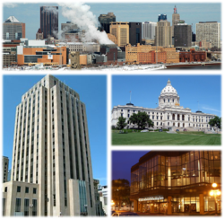
सेन्त पल, मिनेसोता
| सेन्त पल, मिनेसोता |
| — State capital city — |
किपा:Stpaul-logo.svg
City of Saint Paul |
 |

Flag |

Seal |
|
| Nickname(s): "the Capital City", "the Saintly City", "Pig's Eye", "the Silver City" |
| Motto: The most livable city in America.1 |
 Location in Ramsey County and the state of Minnesota.Location in Ramsey County and the state of Minnesota. Location in Ramsey County and the state of Minnesota.Location in Ramsey County and the state of Minnesota.
|
| Location of Saint Paul City Hall in the Minneapolis–Saint Paul metropolitan area
|
| Coordinates: 44°56′38.76″N 93°05′6.72″W / 44.9441000°N 93.0852000°W / 44.9441000; -93.0852000Coordinates: 44°56′38.76″N 93°05′6.72″W / 44.9441000°N 93.0852000°W / 44.9441000; -93.0852000 |
| Country |
United States |
| State |
Minnesota |
| County |
Ramsey |
| Incorporated |
1854 |
| Government |
| - Mayor |
Chris Coleman (DFL) |
| Area[१] |
| - State capital city |
५६.१८ sq mi (१४५.५१ km2) |
| - Land |
५१.९८ sq mi (१३४.६३ km2) |
| - Water |
४.२० sq mi (१०.८८ km2) |
| Elevation |
७०२ ft (२१४ m) |
| Population (2010)[२] |
| - State capital city |
२८५,०६८ |
| - Estimate (2011[३]) |
२८८,४४८ |
| - Rank |
City: 67th
Metro: 16th |
| - Density |
५,४८४.२/sq mi (२,११७.५/km2) |
| - Metro |
३,३१७,३०८ |
| - Demonym |
Saint Paulite |
| Time zone |
CST (UTC-6) |
| - Summer (DST) |
CDT (UTC-5) |
| ZIP codes |
55101–55175 |
| Area code(s) |
651 |
| Website |
www.stpaul.gov |
| 1 Current as of July 30, 2008.[४] |
सेन्त पल मिनेसोताया राजधानी नगर ख।
जलवायु
| Climate data for Saint Paul, Minnesota
|
| Month
|
Jan
|
Feb
|
Mar
|
Apr
|
May
|
Jun
|
Jul
|
Aug
|
Sep
|
Oct
|
Nov
|
Dec
|
Year
|
| Record high °F (°C)
|
57
|
59
|
83
|
93
|
93
|
103
|
105
|
103
|
95
|
88
|
75
|
66
|
Template:Max/१२
|
| Average high °F (°C)
|
23
|
28
|
41
|
58
|
69
|
78
|
83
|
80
|
71
|
58
|
41
|
27
|
५४.८
|
| Average low °F (°C)
|
6
|
12
|
24
|
36
|
48
|
58
|
63
|
61
|
52
|
39
|
26
|
12
|
३६.४
|
| Record low °F (°C)
|
−29
|
−32
|
−25
|
3
|
21
|
36
|
45
|
42
|
26
|
15
|
−14
|
−29
|
Template:Min/१२
|
| Precipitation inches (mm)
|
1.02
|
0.78
|
1.92
|
2.54
|
3.73
|
4.98
|
4.41
|
4.37
|
3.20
|
2.51
|
2.09
|
1.04
|
३२.५९
|
| Source: The Weather Channel [५]
|
जनसंख्या
| Historical populations
|
| Census |
Pop. |
|
%±
|
| 1850 | १,११२ | | — |
| 1860 | १०,४०१ | | ८३५.3% |
| 1870 | २०,०३० | | ९२.6% |
| 1880 | ४१,४७३ | | १०७.1% |
| 1890 | १३३,१५६ | | २२१.1% |
| 1900 | १६३,०६५ | | २२.5% |
| 1910 | २१४,७४४ | | ३१.7% |
| 1920 | २३४,६९८ | | ९.3% |
| 1930 | २७१,६०६ | | १५.7% |
| 1940 | २८७,७३६ | | ५.9% |
| 1950 | ३११,३४९ | | ८.2% |
| 1960 | ३१३,४११ | | ०.7% |
| 1970 | ३०९,९८० | | −१.1% |
| 1980 | २७०,२३० | | −१२.8% |
| 1990 | २७२,२३५ | | ०.7% |
| 2000 | २८७,१५१ | | ५.5% |
| 2010 | २८५,०६८ | | −०.7% |
| Est. 2011 | २८८,४४८ | | १.2% |
U.S. Decennial Census
2011 estimate |
लिधंसा
स्वयादिसँ
संयुक्त राज्य अमेरिकाया राज्यतयेगु राजधानी |
|---|
| | | 1 Federal capital. |
|


