Carroll County (Missouri)
| County in de Verenigde Staten | |||
|---|---|---|---|

| |||
| Situering | |||
| Staat | Missouri | ||
| Coördinaten | 39°25'48"NB, 93°30'0"WL | ||
| Algemeen | |||
| Oppervlakte | 1.819 km² | ||
| - land | 1.799 km² | ||
| - water | 20 km² | ||
| Inwoners (2000) |
10.285 (6 inw./km²) | ||
| Overig | |||
| Zetel | Carrollton | ||
| FIPS-code | 29033 | ||
| Opgericht | 1833 | ||
| Website | www | ||
| Foto's | |||
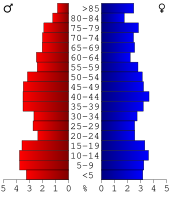 Bevolkingspiramide Carroll County | |||
| Statistieken volkstelling Carroll County | |||
| |||
Carroll County is een county in de Amerikaanse staat Missouri.
De county heeft een landoppervlakte van 1.799 km² en telt 10.285 inwoners (volkstelling 2000). De hoofdplaats is Carrollton.
Bevolkingsontwikkeling
| Jaar | Inwoners | % ± | |
|---|---|---|---|
| 1900 | 26.455 | — | |
| 1910 | 23.098 | −12,7% | |
| 1920 | 20.480 | −11,3% | |
| 1930 | 19.940 | −2,6% | |
| 1940 | 17.814 | −10,7% | |
| 1950 | 15.589 | −12,5% | |
| 1960 | 13.847 | −11,2% | |
| 1970 | 12.565 | −9,3% | |
| 1980 | 12.131 | −3,5% | |
| 1990 | 10.748 | −11,4% | |
| 2000 | 10.285 | −4,3% | |
| Bron: (en) Historical Decennial Census Population | |||