Tangalan
| Tangalan | |||
|---|---|---|---|
 | |||
| Land | |||
| Status | kommune | ||
| Postnummer | 5612 | ||
| Retningsnummer | 36 | ||
| Areal | 74,59 kvadratkilometer | ||
| Befolkning | 23 704[1] (2020) | ||
| Bef.tetthet | 317,79 innb./kvadratkilometer | ||
| Antall husholdninger | 5 808 | ||
| Språk | Aklanon, Hiligaynon, tagalog | ||
| Høyde o.h. | 39 meter | ||
| Nettside | www | ||
 Tangalan 11°46′39″N 122°15′37″Ø | |||
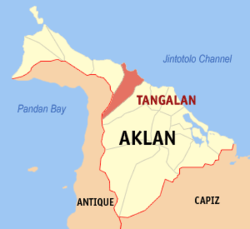
Tangalan (Bayan ng Tangalan) er en kommune på Filippinene. Kommunen ligger på øya Panay, og tilhører provinsen Aklan.
Tangalan var tidligere en arrabal til Makato. Da den ble utskilt omfattet den de følgende barrioene: Tondog, Jawili, Dumatad, Afga, Baybay, Dapdap, Pudyot, Tagas, Tamalagon, Panayakan, Vivo, Lanipga, Napatag og Tamokoe.[2]
Barangayer
Tangalan er inndelt i 15 barangayer.[3]
- Afga
- Baybay
- Dapdap
- Dumatad
- Jawili
- Lanipga
- Napatag
- Panayakan
- Poblacion
- Pudiot
- Tagas
- Tamalagon
- Tamokoe
- Tondog
- Vivo
Referanser
- ^ «2020 Census of Population and Housing (2020 CPH) Population Counts Declared Official by the President». folketellingen 2020. Filippinenes statistikkbyrå. 7. juli 2021.
- ^ «Republic Act No. 285; An Act Creating the Municipality of Tangalan in the Province of Capiz». The Corpus Juris. 16. juni 1948. Besøkt 22. oktober 2016.
- ^ Barangays in Tangalan 2018 Philippine Standard Geographic Code (PSGC)
Kilder
- 2015 Census of Population and Housing Report Philippine Statistics Authority