Parys, Free State
| Parys | |
|---|---|
 NG Mother Church, Hefer Street, Parys | |
 Parys | |
| Coordinates: 26°54′S 27°27′E / 26.900°S 27.450°E | |
| Naga | Afrika Borwa |
| Porofense | Free State |
| Mmasepala wa Selete | Fezile Dabi |
| Mmušôselegae | Ngwathe |
| Hlômile | 1882[1] |
| Sekgôba[2] | |
| • Total | 23.30 km2 (9.00 sq mi) |
| Setšhaba (2011)[2] | |
| • Total | 8,071 |
| • Phitlaganyo | 350/km2 (900/sq mi) |
| Dipersente tša merafe (2011)[2] | |
| • Bathobaso | 13.2% |
| • Bammala | 1.3% |
| • MaIndia | 0.7% |
| • Makgowa | 84.4% |
| • Šele | 0.5% |
| Dipolelo tša ntlha (2011)[2] | |
| • Afrikaans | 84.7% |
| • Seisimane | 6.9% |
| • Sesotho | 5.1% |
| • Šele | 3.3% |
| Nomoro ya poso (Setarata) | 9585 |
| Nomoro ya poso (Lepokisi) | 9585 |
| Khoutu ya lefelo | 056 |
| Website | http://www.parys.co.za |
Parys ke toropo kgolo ya Ngwathe Mmusogae, Mmasepala Setereke tša Fezile Dabi go feta porofense Free State ka moka Afrika Borwa.
Parys e 122 km borwa bohlabela la Johannesburg.
Ditšhupetšo
- ↑ "Chronological order of town establishment in South Africa based on Floyd (1960:20-26)" (PDF). pp. xlv–lii. Archived from the original (PDF) on 2019-07-13. Retrieved 2016-06-14.
- ↑ 2.0 2.1 2.2 2.3 "Main Place Parys". Census 2011.
Bomasepala ba le metseng ea Mmasepala Setereke tša Fezile Dabi, Freistata | ||
|---|---|---|
| District seat: Sasolburg | ||
| Moqhaka | Kroonstad • Maokeng • Matlwangtlwang • Rammulotsi • Steynsrus • Vierfontein • Viljoenskroon | 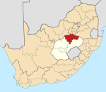 |
| Ngwathe | Edenville • Heilbron • Koppies • Kwakwatsi • Mokwallo • Ngwathe • Parys • Phiritona • Sandersville • Schonkenville • Tumahole • Vredefort | |
| Metsimaholo | Bertha Shaft Village • Deneysville • Holly Country • Kragbron • Liliandale • Oranjeville • Refengkgotso • Richmond • Rietfontein • Sasolburg • Viljoensdrif • Zamdela | |
| Mafube | Cornelia • Frankfort • Mafahlaneng • Namahadi • Ntswanatsatsi • Qalabotjha • Tweeling • Villiers | |