ਕੋਲੋਰਾਡੋ ਦਰਿਆ
| ਕੋਲੋਰਾਡੋ ਦਰਿਆ Colorado River | |
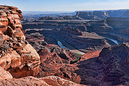 ਯੂਟਾ ਵਿੱਚ ਡੈੱਡ ਹਾਰਸ ਬਿੰਦੂ ਤੋਂ ਵਿਖਦਾ ਦਰਿਆ
| |
| ਦੇਸ਼ | |
|---|---|
| ਰਾਜ | ਕੋਲੋਰਾਡੋ, ਯੂਟਾ, ਐਰੀਜ਼ੋਨਾ, ਨੇਵਾਡਾ, ਕੈਲੀਫ਼ੋਰਨੀਆ, ਹੇਠਲਾ ਕੈਲੀਫ਼ੋਰਨੀਆ, ਸੋਨੋਰਾ |
| ਸਹਾਇਕ ਦਰਿਆ | |
| - ਖੱਬੇ | ਫ਼ਰਾਸਰ ਦਰਿਆ, ਈਗਲ ਦਰਿਆ, ਰੋਰਿੰਗ ਫ਼ੋਰਕ ਦਰਿਆ, ਗਨੀਸਨ ਦਰਿਆ, ਡੋਲਰਸ ਦਰਿਆ, ਸਾਨ ਹੁਆਨ ਦਰਿਆ, ਲਿਟਲ ਕੋਲੋਰਾਡੋ ਦਰਿਆ, ਵਿਗ ਵਿਲੀਅਮਜ਼ ਦਰਿਆ, ਜੀਲਾ ਦਰਿਆ |
| - ਸੱਜੇ | ਹਰਾ ਦਰਿਆ, ਡਰਟੀ ਡੇਵਿਲ ਦਰਿਆ, ਐਸਕਾਲਾਂਤੇ ਦਰਿਆ, ਕੈਨਬ ਦਰਿਆ, ਵਰਜਿਨ ਦਰਿਆ |
| ਸ਼ਹਿਰ | ਗਰੈਂਡ ਜੰਕਸ਼ਨ, ਮੋਬ, ਪੇਜ, ਬੁਲਹੈੱਡ ਸ਼ਹਿਰ, ਹਵਾਸੂ ਝੀਲ ਸ਼ਹਿਰ, ਯੂਮਾ, ਸੈਨ ਲੂਈਸ ਰਿਓ ਕੋਲੋਰਾਡੋ |
| ਸਰੋਤ | ਲਾ ਪੂਦਰ ਦੱਰਾ |
| - ਸਥਿਤੀ | ਰੌਕੀ ਪਹਾੜ, ਕੋਲੋਰਾਡੋ, ਸੰਯੁਕਤ ਰਾਜ |
| - ਉਚਾਈ | 10,184 ਫੁੱਟ (3,104 ਮੀਟਰ) |
| - ਦਿਸ਼ਾ-ਰੇਖਾਵਾਂ | 40°28′20″N 105°49′34″W / 40.47222°N 105.82611°W [1] |
| ਦਹਾਨਾ | ਕੈਲੀਫ਼ੋਰਨੀਆ ਦੀ ਖਾੜੀ |
| - ਸਥਿਤੀ | ਕੋਲੋਰਾਡੋ ਦਰਿਆ ਡੈਲਟਾ, ਬਾਹ ਕੈਲੀਫ਼ੋਰਨੀਆ–ਸੋਨੋਰਾ, ਮੈਕਸੀਕੋ |
| - ਉਚਾਈ | 0 ਫੁੱਟ (0 ਮੀਟਰ) |
| - ਦਿਸ਼ਾ-ਰੇਖਾਵਾਂ | 31°54′00″N 114°57′03″W / 31.90000°N 114.95083°W [1] |
| ਲੰਬਾਈ | 1,450 ਮੀਲ (2,334 ਕਿਮੀ) [2] |
| ਬੇਟ | 2,46,000 ਵਰਗ ਮੀਲ (6,37,137 ਕਿਮੀ੨) [2] |
| ਡਿਗਾਊ ਜਲ-ਮਾਤਰਾ | mouth (virgin flow), max and min at Topock, AZ, 300 mi (480 km) from the mouth |
| - ਔਸਤ | 21,700 ਘਣ ਫੁੱਟ/ਸ (614 ਮੀਟਰ੩/ਸ) [n 1] |
| - ਵੱਧ ਤੋਂ ਵੱਧ | 3,84,000 ਘਣ ਫੁੱਟ/ਸ (10,900 ਮੀਟਰ੩/ਸ) [7] |
| - ਘੱਟੋ-ਘੱਟ | 422 ਘਣ ਫੁੱਟ/ਸ (12 ਮੀਟਰ੩/ਸ) [8] |
 ਕੋਲੋਰਾਡੋ ਬੇਟ ਦਾ ਨਕਸ਼ਾ
| |
ਕੋਲੋਰਾਡੋ ਦਰਿਆ ਦੱਖਣ-ਪੱਛਮੀ ਸੰਯੁਕਤ ਰਾਜ ਅਤੇ ਉੱਤਰ-ਪੱਛਮੀ ਮੈਕਸੀਕੋ ਦਾ ਪ੍ਰਮੁੱਖ ਦਰਿਆ ਹੈ। ਇਹ 1,450 ਕਿਲੋਮੀਟਰ ਦਰਿਆ ਇੱਕ ਵਿਸ਼ਾਲ, ਸੁੱਕੇ ਬੇਟ ਨੂੰ ਸਿੰਜਦਾ ਹੈ ਜੋ ਸੱਤ ਅਮਰੀਕੀ ਅਤੇ ਦੋ ਮੈਕਸੀਕੀ ਰਾਜਾਂ ਵਿੱਚ ਫੈਲਿਆ ਹੋਇਆ ਹੈ। ਇਹਦਾ ਸਰੋਤ ਸੰਯੁਕਤ ਰਾਜ ਵਿੱਚ ਰੌਕੀ ਪਹਾੜਾਂ ਵਿੱਚ ਹੈ ਜਿਸ ਮਗਰੋਂ ਇਹ ਕੋਲੋਰਾਡੋ ਪਠਾਰ ਵਿੱਚ ਦੱਖਣ-ਪੱਛਮ ਵੱਲ ਵਗਦਾ ਹੋਇਆ ਐਰੀਜ਼ੋਨਾ-ਨੇਵਾਡਾ ਰੇਖਾ ਉੱਤੇ ਮੀਡ ਝੀਲ ਤੱਕ ਪਹੁੰਚਦਾ ਹੈ ਜਿੱਥੋਂ ਇਹ ਦੱਖਣ ਵੱਲ ਮੋੜ ਖਾ ਕੇ ਅੰਤਰਰਾਸ਼ਟਰੀ ਸਰਹੱਦ ਵੱਲ ਤੁਰ ਪੈਂਦਾ ਹੈ। ਮੈਕਸੀਕੋ ਪੁੱਜਣ ਉੱਤੇ ਇਹ ਇੱਕ ਵਿਸ਼ਾਲ ਡੈਲਟਾ ਬਣਾ ਕੇ ਬਾਹਾ ਕੈਲੀਫ਼ੋਰਨੀਆ ਅਤੇ ਸੋਨੋਰਾ ਵਿਚਕਾਰ ਕੈਲੀਫ਼ੋਰਨੀਆ ਦੀ ਖਾੜੀ ਵਿੱਚ ਜਾ ਡਿੱਗਦਾ ਹੈ।
ਹਵਾਲੇ
- ↑ 1.0 1.1 "Colorado River". Geographic Names Information System. United States Geological Survey. 1980-02-08. Retrieved 2012-02-18.
- ↑ 2.0 2.1 Kammerer, J.C. "Largest Rivers in the United States". U.S. Geological Survey. Retrieved 2010-07-02.
- ↑ "A preliminary water balance for the Colorado River delta, 1992–1998" (PDF). Journal of Arid Environments. 2001 (49): 35–48.
{cite journal}: Cite uses deprecated parameter|authors=(help) - ↑ "Colorado River Watershed" (PDF). Arizona Department of Water Resources. Archived from the original (PDF) on 2013-01-20. Retrieved 2012-04-27.
{cite web}: Unknown parameter|dead-url=ignored (|url-status=suggested) (help) - ↑ "Bill Williams Watershed" (PDF). Arizona Department of Water Resources. Archived from the original (PDF) on 2013-09-21. Retrieved 2012-04-27.
{cite web}: Unknown parameter|dead-url=ignored (|url-status=suggested) (help) - ↑ Rush, F. Eugene (1964-07). "Ground-Water Appraisal of the Meadow Valley Area, Lincoln and Clark Counties, Nevada" (PDF). State of Nevada Division of Water Resources. p. 16. Retrieved 2012-04-27.
{cite web}: Check date values in:|date=(help) - ↑ Hoover Dam 75th Anniversary History Symposium 2010, p. 102.
- ↑ "USGS Gage #09424000 on the Colorado River near Topock, AZ – Daily Data". National Water।nformation System. U.S. Geological Survey. 1935-02-14. Retrieved 2012-04-21.
Preview of references
- ↑ The combined natural flows of the Colorado River at Lee's Ferry, Arizona and the Gila River at the mouth are about 15.1 million acre-feet (18.63 km3 per year.[3] Although this amounts to most of the river's natural discharge, several significant tributaries do enter between Lee's Ferry and the Gila River, including the Little Colorado, Virgin and Bill Williams Rivers. These tributaries combined contribute an estimated 561,000 acre feet (0.69 km3) each year,[4][5][6] bringing the total annual discharge from the entire river system to 15.7 million acre-feet (19.32 km3), corresponding to an average flow of 21,700 cu ft/s (610 m3/s).