Huy (okręg)
Huy
fr. Arrondissement administratif de Huy
nld. Arrondissement Hoei
niem. Bezirk Huy
| okręg
|
|
| Państwo
|
 Belgia Belgia
|
| Region
|
Waloński
|
| Prowincja
|
Liège
|
| Powierzchnia
|
661,20 km²
|
Populacja (1 stycznia 2024)
• liczba ludności
|
115 830[1]
|
| • gęstość
|
175 os./km²
|
Położenie na mapie
|
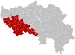
Huy (fr. Arrondissement administratif de Huy, nld. Arrondissement Hoei, niem. Bezirk Huy) – okręg w północnej Belgii, w Regionie Walońskim, w prowincji Liège.
Podział administracyjny
Okręg podzielony jest na 17 gmin (nld. gemeente, fr. commmune, niem. Gemeinde), w skład których wchodzi 55 dzielnic (deelgemeente)
- Amay
- Ampsin
- Flône
- Jehay
- Ombret-Rawsa
- Anthisnes
- Hody
- Tavier
- Villers-aux-Tours
- Burdinne
- Hannêche
- Lamontzée
- Marneffe
- Oteppe
- Clavier
- Bois-et-Borsu
- Les Avins
- Ocquier
- Pailhe
- Terwagne
- Engis
- Clermont-sous-Huy
- Hermalle-sous-Huy
- Ferrières
- My
- Vieuxville
- Werbomont
- Xhoris
|
- Hamoir
- Héron
- Couthuin
- Lavoir
- Waret-l'Évêque
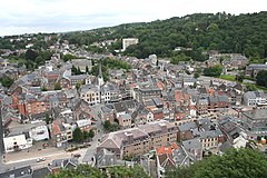
- Huy (Hoei)
- Ben-Ahin
- Seraing-le-Château
- Soheit-Tinlot
- Tihange
- Marchin
- Modave
- Outrelouxhe
- Strée
- Vierset-Barse
- Nandrin
- Saint-Séverin
- Villers-le-Temple
- Yernée-Fraineux
- Ouffet
|
|
Przypisy
Gminy
Gemeente / commune / Gemeinde |
|
|---|
Dzielnice
Deelgemeente |
- Abée
- Ampsin
- Antheit
- Bas-Oha
- Ben-Ahin
- Bodegnée
- Bois-et-Borsu
- Chapon-Seraing
- Clermont-sous-Huy
- Comblain-Fairon
- Couthuin
- Ellemelle
- Filot
- Fize-Fontaine
- Flône
- Fraiture
- Hannêche
- Hermalle-sous-Huy
- Hody
- Huccorgne
- Jehay
- Lamontzée
- Lavoir
- Les Avins
- Marneffe
- Moha
- My
- Ocquier
- Ombret-Rawsa
- Oteppe
- Outrelouxhe
- Pailhe
- Ramelot
- Saint-Séverin
- Seny
- Seraing-le-Château
- Soheit-Tinlot
- Strée
- Tavier
- Terwagne
- Tihange
- Vaux-et-Borset
- Vieux-Waleffe
- Vierset-Barse
- Vieuxville
- Villers-aux-Tours
- Villers-le-Temple
- Vinalmont
- Vyle-et-Tharoul
- Waret-l'Évêque
- Werbomont
- Xhoris
- Yernée-Fraineux
- Warnant-Dreye
- Warzée
|
|---|
Siedziba prowincji: Liège (Luik / Lüttich)
Okręgi
Arrondissement / Bezirk |
|
|---|


