Anzoátegui
{official_name} {native_name} | |
|---|---|
 | |
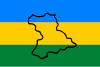 Banner  Coat airms | |
| Motto(s): Tumba de sus tiranos (Inglis: Tomb of its tyrants) | |
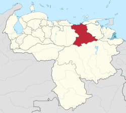 Location athin Venezuela | |
| Kintra | Venezuela |
| Created | 1909 |
| Caipital | Barcelona |
| Govrenment | |
| • Govrenor | Tarek William Saab (2008–2012) |
| Area | |
| • Total | 43300 km2 (16,700 sq mi) |
| Area rank | 6th |
| 4.72% of Venezuela | |
| Population (2007 est.) | |
| • Total | 1,477,900 |
| • Rank | 8th |
| 5.3% o Venezuela | |
| Time zone | UTC-04:00 |
| ISO 3166 code | VE-B |
| Emblematic tree | Cereipo, or Guatamare (Myrospermum fructescens) |
| Website | www |
Anzoátegui State (Spaingie: Estado Anzoátegui, IPA: [esˈtaðo ansoˈateɣi]), is ane o the 23 component states o Venezuela, locatit in the northeastren region o the kintra. Anzoátegui is weel kent for its bonnie beaches that attract mony visitors. Its coast consists o a single beach approximately 100 km lang. Its caipital is the ceety o Barcelona, an significant ceeties include Puerto la Cruz an El Tigre.
Municipalities an municipal seats
Anzoátegui comprises 21 municiplities (municipios), leetit belaw:
- Anaco (Anaco)
- Aragua (Aragua de Barcelona)
- Diego Bautista Urbaneja (Lechería)
- Fernando de Peñalver (Puerto Píritu)
- Francisco de Carmen Carvajal (Valle de Guanape)
- Francisco de Miranda (Pariaguán)
- Guanipa (San José de Guanipa)
- Guanta (Guanta)
- Independencia (Soledad)
- José Gregorio Monagas (Mapire)
- Juan Antonio Sotillo (Puerto la Cruz)
- Juan Manuel Cajigal (Onoto)
- Libertad (San Mateo)
- Manuel Ezequiel Bruzual (Clarines)
- Pedro María Freites (Cantaura)
- Píritu (Píritu)
- San Juan de Capistrano (Boca de Uchire)
- Santa Ana (Santa Ana)
- Simón Bolívar (Barcelona)
- Simón Rodríguez (El Tigre)
- Sir Arthur McGregor (El Chaparro)
See an aw
Freemit airtins
- General information aboot Anzoátegui
- Census data of Anzoátegui Archived 2004-02-04 at the Wayback Machine
Admeenistrative diveesions o Venezuela | ||
|---|---|---|
| Caipital Destrict | ||
| States | ||
| Dependencies |
| |
| Regions |
| |
| Claimit |
| |