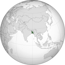
Bangladesh
Coordinates: 23°48′N 90°18′E / 23.8°N 90.3°E
Fowkrepublic o Bangladesh
| |
|---|---|
 | |
| Caipital and largest city | Dhaka 23°42′N 90°21′E / 23.700°N 90.350°E |
| Offeecial leid an naitional leid | Bengali[2] |
| Ethnic groups | |
| Releegion |
|
| Demonym(s) | Bangladeshi |
| Govrenment | Unitar pairlamentar republic |
• Preses | Abdul Hamid |
• Prime Meenister | Waker-uz-Zaman |
• Hoose Speaker | Shirin Sharmin Chaudhury |
• Chief Juistice | Surendra Kumar Sinha |
| Legislatur | Jatiya Sangsad |
Formation an unthirldom | |
• Pairteetion o Bengal an end o the Breetish Raj | 14–15 August 1947 |
• Unthirldom declared frae Pakistan | 26 March 1971 |
• Recognized | 16 December 1971 |
• Constitution | 4 November 1972 |
• Last territorial admission | 31 July 2015 |
| Aurie | |
• Total | 147,610[4] km2 (56,990 sq mi) (92nt) |
• Water (%) | 6.4 |
| Population | |
• 2017 estimate | 163,187,000[5] (8t) |
• 2011 census | 149,772,364[6] (8t) |
• Density | 1,106/km2 (2,864.5/sq mi) (10t) |
| GDP (PPP) | 2017 estimate |
• Total | $686.598 billion[7] (33rd) |
• Per capita | $4,207[7] (139t) |
| GDP (nominal) | 2017 estimate |
• Tot | $248.853 billion[7] (45t) |
• Per capita | $1,524[7] (148t) |
| Gini (2010) | 32.1[8] medium |
| HDI (2016) | medium · 139t |
| Currency | Taka (৳) (BDT) |
| Time zone | UTC+6 (BST) |
| Date format |
|
| Drivin side | left |
| Cawin code | +880 |
| ISO 3166 code | BD |
| Internet TLD | .bd .বাংলা |
Wabsteid bangladesh | |

Bangladesh (pronounced /ˈbɑːŋɡlədɛʃ/ (deprecatit template) or /bæŋɡləˈdɛʃ/ (![]() listen); Bengali: বাংলাদেশ), offeecially the Fowkrepublic o Bangladesh (Bangla: গণপ্রজাতন্ত্রী বাংলাদেশ Gônoprojatontri Bangladesh) is a kintra in Sooth Asie. It is bordered bi Indie on aw sides except for a sma border wi Burma (Myanmar) tae the far sootheast an bi the Bay o Bengal tae the sooth. Thegither wi the Indian state o Wast Bengal, it makes up the ethno-linguistic region o Bengal. The name Bangladesh means "Kintra o Bengal" in the offeecial Bengali leid.
listen); Bengali: বাংলাদেশ), offeecially the Fowkrepublic o Bangladesh (Bangla: গণপ্রজাতন্ত্রী বাংলাদেশ Gônoprojatontri Bangladesh) is a kintra in Sooth Asie. It is bordered bi Indie on aw sides except for a sma border wi Burma (Myanmar) tae the far sootheast an bi the Bay o Bengal tae the sooth. Thegither wi the Indian state o Wast Bengal, it makes up the ethno-linguistic region o Bengal. The name Bangladesh means "Kintra o Bengal" in the offeecial Bengali leid.
References
- ↑ "NATIONAL SYMBOLS→National march". Bangladesh Tourism Board. Bangladesh: Ministry of Civil Aviation & Tourism. Archived frae the original on 28 December 2016. Retrieved 30 August 2017.
In 13 January 1972, the ministry of Bangladesh has adopted this song as a national marching song on its first meeting after the country's independence.
- ↑ "Article 3. The state language". The Constitution of the People's Republic of Bangladesh. bdlaws.minlaw.gov.bd. Ministry of Law, The People's Republic of Bangladesh. Retrieved 1 Februar 2017.
- ↑ a b "জানুন (Discover Bangladesh)" (in Bengali). National Web Portal of Bangladesh. Retrieved 13 Februar 2015.
- ↑ "Archived copy" (PDF). Archived frae the original (PDF) on 22 October 2016. Retrieved 30 August 2017.CS1 maint: archived copy as title (link)
- ↑ "Bangladesh" IMF Population estimates.
- ↑ Data Archived 4 September 2011 at the Wayback Machine.Census – Bangladesh Bureau of Statistics.
- ↑ a b c d "Bangladesh". World Economic Outlook Database. IMF.
- ↑ "Gini Index". World Bank. Archived frae the original on 9 Februar 2015. Retrieved 2 Mairch 2011.
- ↑ "Human Development Report 2016" (PDF). United Nations Development Programme. 2016. Retrieved 6 Apryle 2017.


