Masally Rayon
Masally Masallı | |
|---|---|
 | |
| Kintra | |
| Area | |
| • Total | 721 km2 (278 sq mi) |
| Population (2005) | |
| • Total | 184 900 |
| • Density | 158/km2 (410/sq mi) |
| Time zone | UTC+4 (GMT+4) |
| • Summer (DST) | UTC+5 (GMT+5) |


Masally (Masallı) is an destrict in the sooth o Azerbaijan
Geography
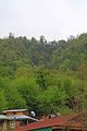
This territory haes mairches wi Lankaran, Lerik, Yardimli, Jalilabad, Neftchala districts. In the east, the destrict is washed bi the Caspian Sea, an in the wast it approaches Talysh Muntains, Burovar rig. Hicht o the territory reaks 917 m. Thare mineral an geothermal springs in Masally. Average temperatur is 2,5 °C in Januar, an 25,6 °C in Julie. The amunt o annual precipitation is 600–800 mm. Vilash is the lairgest river o the destrict. Thare braid-leavit forests o Girkan type-chestane-leaved aik, hornbeam, beech, Persie ironwood tree, Girkan boxwood, Caucasian persimmon, medlar an ithers in the muntainous pairt o the destrict. Tot aurie o the destrict's forests equals tae 16,9 thoosan acre.
History
Masally rayon wis oreeginatit in 1930. Aforehaun, the territory o the destrict wis the pairt o Arkevan aurie o Lankaran rayon.
State poleetical seestem
The heid o Masally rayon is chief executive. Chief executives:
- Safarov Azer Fattah oglu-till September 30, 2004]
- Aliyev Ogtay Jalil oglu-frae Semtember 30, 2004 tae September 29, 2006
- Agayev Gazanfar Arif oglu-syne September 30, 2006[1]
Admeenistrative structur
The centre o the destrict is ceety Masally. Average population density is 158 fowk per km². Boradigah tounship, Arkevan, Banbashi, Gizilagaj, Teze Alvadi veelages are the ither lairgest population aggregates.
Photos


References
- ↑ "Президент Азербайджана усилил исполнительную власть в Масаллинском районе". 29 сентября 2006 г. Check date values in:
|date=(help)
| Destricts (Raions) |  Absheron · Agdam · Agdash · Aghjabadi · Agstafa · Agsu · Astara · Babek · Balakan · Barda · Beylagan · Bilasuvar · Dashkasan · Fizuli · Gadabay · Goranboy · Goychay · Goygol · Hajigabul · Imishli · Ismailli · Jabrayil · Jalilabad · Julfa · Kalbajar · Kangarli · Khachmaz · Khizi · Khojali · Khojavend · Kurdamir · Lachin · Lankaran · Lerik · Masally · Neftchala · Oghuz · Ordubad · Qabala · Qakh · Qazakh · Gobustan · Quba · Qubadli · Qusar · Saatly · Sabirabad · Sadarak · Salyan · Samukh · Shabran · Shakhbuz · Shaki · Shamakhi · Shamkir · Sharur · Shusha · Siazan · Tartar · Tovuz · Ujar · Yardymli · Yevlakh · Zangilan · Zaqatala · Zardab |
|---|---|
| Ceeties | |
Names in italics indicate pairts o the Nakhchivan Autonomous Republic | |
Template:Masally Rayon