Skaftárhreppur
Skaftárhreppur
Municipality
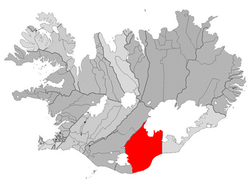
Location o the Municipality o Skaftárhreppur
Kintra Iceland Constituency[ 1] Suðurkjördæmi Region[ 2] Suðurland Coonty Vestur-Skaftafellssýsla Area
• Total 6,946 km2 (2,682 sq mi) Population (Januar 2011)
• Total 446 Time zone UTC+0 (GMT )Post Code 880
Skaftárhreppur is a municipality in soothren Iceland .
As o Januar 2011, it haed a total population o 446 an a population density o 0.07 per square kilometre. The total aurie wis 6946 km². The lairgest dounset is Kirkjubæjarklaustur.
References
↑ Political division
↑ Mainly statistical diveesion
Akrahreppur
Akranes
Akureyri Álftanes Árborg
Árneshreppur
Ásahreppur
Bæjarhreppur
Bláskógabyggð
Blönduós
Bolungarvík
Borgarbyggð
Borgarfjarðarhreppur
Breiðdalshreppur
Dalabyggð
Dalvík
Djúpivogur
Eyja- og Miklaholtshreppur
Eyjafjarðarsveit
Fjallabyggð
Fjarðabyggð
Fljótsdalshérað
Fljótsdalshreppur
Flóahreppur
Garðabær
Garður Grímsnes- og Grafningshreppur
Grindavík
Grundarfjörður
Grýtubakkahreppur
Hafnarfjörður
Helgafellssveit
Höfn
Hörgársveit
Hrunamannahreppur
Húnaþing vestra
Húnavatnshreppur
Hvalfjarðarsveit
Hveragerði
Ísafjarðarbær Kaldrananeshreppur Kjósarhreppur Kópavogur Langanesbyggð
Mosfellsbær
Mýrdalshreppur
Norðurþing
Ölfus
Rangárþing eystra
Rangárþing ytra
Reykhólahreppur
Reykjanesbær
Reykjavík Sandgerði
Seltjarnarnes Seyðisfjörður
Skaftárhreppur Skagabyggð
Skagafjörður
Skagaströnd
Skeiða- og Gnúpverjahreppur
Skorradalshreppur
Skútustaðahreppur
Snæfellsbær Strandabyggð
Stykkishólmur
Súðavík
Svalbarðshreppur
Svalbarðsstrandarhreppur
Tálknafjarðarhreppur
Þingeyjarsveit
Tjörneshreppur
Vestmannaeyjar
Vesturbyggð
Vogar
Vopnafjörður
Coordinates : 63°47′20″N 18°03′14″W / 63.789°N 18.054°W / 63.789; -18.054
The article is a derivative under the Creative Commons Attribution-ShareAlike License .
A link to the original article can be found here and attribution parties here
By using this site, you agree to the Terms of Use . Gpedia ® is a registered trademark of the Cyberajah Pty Ltd
