Camarines Sur
Camarines Sur | |
|---|---|
| Province of Camarines Sur | |
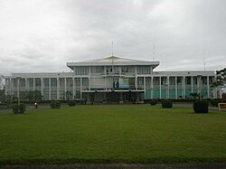 Camarines Sur Provincial Capitol | |
 Flag | |
 Location in the Philippines | |
| Coordinates: 13°40′N 123°20′E / 13.67°N 123.33°E | |
| Country | Philippines |
| Region | Bicol Region (Region V) |
| Founded (Separated from Ambos Camarines) | March 19, 1919 |
| Capital | Pili |
| Government | |
| • Type | Sangguniang Panlalawigan |
| • Governor | Miguel Luis R. Villafuerte (NP) |
| • Vice Governor | Imelda A. Papin |
| Area | |
| • Total | 5,497.03 km2 (2,122.42 sq mi) |
| • Rank | 16th out of 81 |
| Highest elevation (Mount Isarog) | 2,011.7 m (6,600.1 ft) |
| Population (2020 census) | |
| • Total | 2,068,244 |
| • Rank | 13th out of 81 |
| • Density | 380/km2 (970/sq mi) |
| • Rank | 19th out of 81 |
| Includes independent component city | |
| Divisions | |
| • Independent cities | 1
|
| • Component cities | 1
|
| • Municipalities | 35
|
| • Barangays |
|
| • Districts | 1st to 5th districts of Camarines Sur (shared with Naga City) |
| Time zone | UTC+8 (PST) |
| IDD : area code | +63 (0)54 |
| ISO 3166 code | PH-CAS |
| Spoken languages | |
| Website | camarinessur |
Camarines Sur (Central Bikol: Habagatan na Camarines; Tagalog: Timog Camarines) is a province in the Philippines located in the Bicol Region in Luzon. Its capital is Pili.
References
- ↑ "List of Provinces". PSGC Interactive. Makati City, Philippines: National Statistical Coordination Board. Archived from the original on 11 January 2013. Retrieved 13 February 2013.