Cherokee County, North Carolina
Cherokee County | |
|---|---|
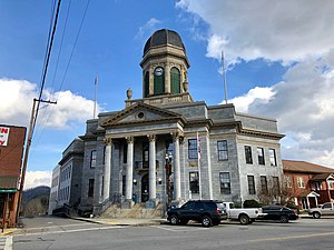 Cherokee County Courthouse in Murphy | |
 Location within the U.S. state of North Carolina | |
 North Carolina's location within the U.S. | |
| Coordinates: 35°08′14″N 84°03′41″W / 35.13715°N 84.061449°W | |
| Country | |
| State | |
| Founded | 1839 |
| Named for | Cherokee Indians |
| Seat | Murphy |
| Largest community | Andrews |
| Area | |
| • Total | 466.67 sq mi (1,208.7 km2) |
| • Land | 455.54 sq mi (1,179.8 km2) |
| • Water | 11.13 sq mi (28.8 km2) 2.38% |
| Population (2020) | |
| • Total | 28,774 |
| • Density | 63.16/sq mi (24.39/km2) |
| Time zone | UTC−5 (Eastern) |
| • Summer (DST) | UTC−4 (EDT) |
| Congressional district | 11th |
| Website | www |
Cherokee County is a county in the U.S. state of North Carolina. In 2020, 28,774 people lived there.[1] Its county seat is Murphy.
History
The county was made in 1839 from the western part of Macon County. In 1861 the southeastern part of Cherokee County became Clay County and in 1872 its northeastern part became Graham County.
Government
Cherokee County is part of the local Southwestern Commission.
Connected counties
These counties are connected to Cherokee County:
- Graham County, North Carolina - northeast
- Macon County, North Carolina - east
- Clay County, North Carolina - southeast
- Union County, Georgia - south-southeast
- Fannin County, Georgia - south-southwest
- Polk County, Tennessee - west
- Monroe County, Tennessee - northwest
Cities and towns
These cities and towns are in Cherokee County:
- Andrews
- Murphy
- Owl Creek
References
- ↑ "QuickFacts: Cherokee County, North Carolina". United States Census Bureau. Retrieved January 17, 2024.

