Dordogne (river)
| Dordogne La Dordogne | |
|---|---|
 The Dordogne in Périgord, near Castelnaud-la-Chapelle | |
 Location of the Dordogne in France | |
| Location | |
| Country | France |
| Physical characteristics | |
| Source | |
| - location | Massif Central |
| - elevation | 1,720 m (5,640 ft) |
| Mouth | |
| - location | Gironde estuary |
| - coordinates | 45°2′29″N 0°36′24″W / 45.04139°N 0.60667°W |
| Length | 483 km (300 mi) |
| Basin size | 23,870 km2 (9,220 sq mi) |
| Discharge | |
| - average | 450 m3/s (16,000 cu ft/s) |
The Dordogne (Occitan: Dordonha) is a river in south-central and southwest France. The Dordogne river and its drainage basin was named as a Biosphere Reserve by the UNESCO on 11 July 2012.[1]
Geography
The Dordogne has a length of 483 km (300.1 mi), and a drainage basin with an area of approximately 23,957 km2 (9,250 sq mi).[2]
Its average yearly discharge (volume of water which passes through a section of the river per unit of time) is 274 cubic metres per second at Bergerac.[3]
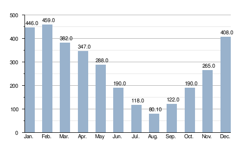
Average monthly discharge (m3/s) at Bergerac (1958-2011)[3]
Course

The Dordogne starts on the sides of the Puy de Sancy, Massif Central, in the commune of Mont-Dore, Puy-de-Dôme department, at an elevation of about 1,380 m (4,528 ft).[4]
It flows generally west through the Nouvelle-Aquitaine region and the Dordogne department before flowing into the Gironde where it joins, in the north of the city of Bordeaux, the Garonne river to form the Gironde estuary, at about 1 m (3 ft) of altitude.[5]
The Dordogne flows through 4 regions, 6 departments and 173 communes.[2] The main communes are:
- Auvergne-Rhône-Alpes region
- Puy-de-Dôme: Mont-Dore, La Bourboule, La Bourboule, Avèze, Singles, Larodde, Labessette
- Cantal: Beaulieu, Lanobre, Madic, Saint-Pierre, Champagnac, Veyrières, Arches, Chalvignac
- Nouvelle-Aquitaine region
- Corrèze: Bort-les-Orgues, Saint-Julien-près-Bort, Liginiac, Neuvic, Soursac, Argentat, Beaulieu-sur-Dordogne
- Occitanie region
- Nouvelle-Aquitaine region
- Dordogne: Carlux, Domme, La Roque-Gageac, Beynac-et-Cazenac, Saint-Cyprien, Le Buisson-de-Cadouin, Mauzac-et-Grand-Castang, Lalinde, Mouleydier, Creysse, Bergerac, Prigonrieux
- Gironde: Sainte-Foy-la-Grande, Castillon-la-Bataille, Libourne, Fronsac, Saint-André-de-Cubzac, Bourg, Cubzac-les-Ponts
Main tributaries
The main tributaries (more than 50 km long) of the Dordogne river are:
Gallery
-
 The Dordogne near the town of Mont-Dore
 -
 The Dordogne and the Beynac castle
 -
 Meyronne and the Dordogne
 -
 Confluence of the Dordogne and the Isle rivers


Related pages
References
- ↑ "Bassin de la Dordogne (France)". UNESCO. Retrieved 17 April 2015.
- ↑ 2.0 2.1 "La Dordogne (P---0000)" (in French). SANDRE - Portail national d'accès aux référentiels sur l'eau. Archived from the original on 3 March 2016. Retrieved 17 April 2015.
- ↑ 3.0 3.1 "La Dordogne à Bergerac" (in French). Banque Hydro. Archived from the original on 30 April 2015. Retrieved 17 April 2015.
- ↑ "Source de la Dordogne" (in French). Géoportail. Retrieved 17 April 2015.
- ↑ "Confluence de la Dordogne" (in French). Géoportail. Retrieved 17 April 2015.
- ↑ "Rivière La Rhue (P0--0250)" (in French). SANDRE - Portail national d'accès aux référentiels sur l'eau. Retrieved 17 April 2015.
- ↑ "La Maronne (P1--0250)" (in French). SANDRE - Portail national d'accès aux référentiels sur l'eau. Retrieved 17 April 2015.
- ↑ "La Cère (P1--0290)" (in French). SANDRE - Portail national d'accès aux référentiels sur l'eau. Retrieved 17 April 2015.
- ↑ "Le Céou (P24-0400)" (in French). SANDRE - Portail national d'accès aux référentiels sur l'eau. Retrieved 17 April 2015.
- ↑ "Le Chavanon (P00-0400)" (in French). SANDRE - Portail national d'accès aux référentiels sur l'eau. Retrieved 17 April 2015.
- ↑ "La Diège (P07-0400)" (in French). SANDRE - Portail national d'accès aux référentiels sur l'eau. Retrieved 17 April 2015.
- ↑ "La Triouzoune (P09-0400)" (in French). SANDRE - Portail national d'accès aux référentiels sur l'eau. Retrieved 17 April 2015.
- ↑ "La Luzège (P11-0400)" (in French). SANDRE - Portail national d'accès aux référentiels sur l'eau. Retrieved 17 April 2015.
- ↑ "Le Doustre (P13-0400)" (in French). SANDRE - Portail national d'accès aux référentiels sur l'eau. Retrieved 17 April 2015.
- ↑ "La Vézère (P---0100)" (in French). SANDRE - Portail national d'accès aux référentiels sur l'eau. Archived from the original on 3 March 2016. Retrieved 17 April 2015.
- ↑ "L'Isle (P---0150)" (in French). SANDRE - Portail national d'accès aux référentiels sur l'eau. Retrieved 17 April 2015.
Other websites
- Banque Hydro - Station P5140010 - La Dordogne à Bergerac Archived 2015-02-19 at the Wayback Machine (in French)
- The Dordogne Valley in the Lot department (in French)
- The Dordogne Valley UNESCO Biosphere Reserve (in French)