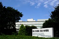
Geospatial Information Authority of Japan

The Geospatial Information Authority of Japan (国土地理院, Kokudo Chiri-in) or GSI is the national institution responsible for surveying and mapping the land and geography of Japan. The main offices of GSI are in Tsukuba City of Ibaraki Prefecture.
From 1949 through May 2010, it was known as the "Geographical Survey Institute".[1]
GSI is part of the Ministry of Land, Infrastructure, Transport and Tourism.
Related pages
References
- ↑ Komaki, Kasuo. New English Appellation of the Geographical Survey Institute Archived 2012-05-11 at the Wayback Machine, 5 March 2010; retrieved 2012-2-4.
Other websites