Gooding County, Idaho
Gooding County | |
|---|---|
 Hagerman Fossil Beds National Monument | |
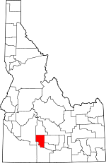
 Location within the U.S. state of Idaho | |
 Idaho's location within the U.S. | |
| Coordinates: 42°58′N 114°48′W / 42.97°N 114.8°W | |
| Country | |
| State | |
| Founded | January 28, 1913 |
| Named for | Frank R. Gooding |
| Seat | Gooding |
| Largest city | Gooding |
| Area | |
| • Total | 734 sq mi (1,900 km2) |
| • Land | 729 sq mi (1,890 km2) |
| • Water | 4.7 sq mi (12 km2) 0.6% |
| Population (2020) | |
| • Total | 15,598 |
| • Density | 21/sq mi (8.2/km2) |
| Time zone | UTC−7 (Mountain) |
| • Summer (DST) | UTC−6 (MDT) |
| Congressional district | 2nd |
| Website | www |
Gooding County is a county in the U.S. state of Idaho. In the 2020 census, the population was 15,598.[1] Its county seat is Gooding.[2] It is named for Frank R. Gooding, an early 20th Century governor and United States Senator from Idaho.
Communities
References
- ↑ "QuickFacts: Gooding County, Idaho". United States Census Bureau. Retrieved September 25, 2023.
- ↑ "Find a County". National Association of Counties. Retrieved 2011-06-07.

