Knœrsheim
Knœrsheim
Knersche | |
|---|---|
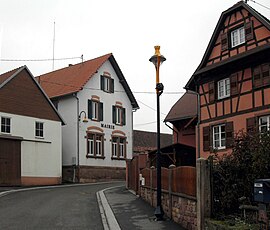 The town hall in Knœrsheim | |
 Coat of arms | |
 Knœrsheim  Knœrsheim | |
| Coordinates: 48°40′54″N 7°27′42″E / 48.6817°N 7.4617°E | |
| Country | France |
| Region | Grand Est |
| Department | Bas-Rhin |
| Arrondissement | Molsheim |
| Canton | Saverne |
| Intercommunality | Mossig et Vignoble |
| Government | |
| • Mayor (2020–2026) | Georges Robitzer |
| Area 1 | 2.36 km2 (0.91 sq mi) |
| Population (Jan. 2019)[1] | 207 |
| • Density | 88/km2 (230/sq mi) |
| Time zone | UTC+01:00 (CET) |
| • Summer (DST) | UTC+02:00 (CEST) |
| INSEE/Postal code | 67245 /67310 |
| Elevation | 196–285 m (643–935 ft) |
| 1 French Land Register data, which excludes lakes, ponds, glaciers > 1 km2 (0.386 sq mi or 247 acres) and river estuaries. | |
Knœrsheim (German: Knörsheim; Alsatian: Knersche) is a commune. It is in Grand Est in the Bas-Rhin department in northeast France.
Geography
Knœrsheim is placed about twelve kilometres (7.5 miles) to the southeast of Saverne. Neighbouring communes are Westhouse-Marmoutier to the north, Zeinheim to the east, Rangen to the southeast, Zehnacker to the south and Jetterswiller to the west.
Sights
- The church of Saint Michel

Related pages
References
- ↑ "Populations légales 2019". The National Institute of Statistics and Economic Studies. 29 December 2021.
Wikimedia Commons has media related to Knœrsheim.