Lockland, Ohio
Lockland, Ohio | |
|---|---|
Village | |
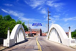 Entrance to Lockland along the Benson Street Bridge | |
 Location in Hamilton County and the state of Ohio | |
| Coordinates: 39°13′35″N 84°27′19″W / 39.22639°N 84.45528°W | |
| Country | United States |
| State | Ohio |
| County | Hamilton |
| Platted | 1828 |
| Incorporated | 1849[1] |
| Government | |
| • Type | Mayor/Council |
| • Mayor | Mark Mason (R)[2][1] |
| Area | |
| • Total | 1.22 sq mi (3.16 km2) |
| • Land | 1.22 sq mi (3.16 km2) |
| • Water | 0.00 sq mi (0.00 km2) |
| Elevation | 581 ft (177 m) |
| Population (2010) | |
| • Total | 3,449 |
| • Estimate (2019) | 3,441 |
| • Density | 2,822.9/sq mi (1,089.93/km2) |
| Time zone | UTC-5 (Eastern (EST)) |
| • Summer (DST) | UTC-4 (EDT) |
| ZIP code | 45215 |
| Area code | 513 |
| FIPS code | 39-44366[5] |
| GNIS feature ID | 1059632[4] |
| Website | www |
Lockland is a village in Hamilton County, Ohio, United States. The population was 3,449 at the 2010 United States Census.[6] Lockland is located in southwest Ohio, north of Cincinnati. Its population has declined since the latter part of the 20th century.
References
- ↑ 1.0 1.1 "Lockland". The Cincinnati Report. Archived from the original on 7 June 2021. Retrieved 7 June 2021.
- ↑ "Hamilton County Officials 2016" (PDF). Hamilton County Board of Elections. 27 January 2016. p. 36. Archived from the original (PDF) on 26 January 2022. Retrieved 1 February 2016.
- ↑ "2019 US Gazetteer Files". United States Census Bureau. Retrieved 28 July 2020.
- ↑ 4.0 4.1 "US Board on Geographic Names". USGS. 25 October 2007. Retrieved 31 January 2008.
- ↑ "US Census website". US Census Bureau. Retrieved 31 January 2008.
- ↑ "Profile of General Population and Housing Characteristics: 2010 Demographic Profile Data: Lockland village, Ohio". US Census Bureau. Retrieved 1 November 2012.
Municipalities and communities of Hamilton County, Ohio, United States | ||
|---|---|---|
| Cities |
|  |
| Villages |
| |
| Townships |
| |
| CDPs |
| |
| Other communities |
| |
| Footnotes | ‡This populated place also has portions in an adjacent county or counties | |