Meuse
| Meuse Meuse (French) Moûze (Walloon) Maas (Dutch) Maos (Limburgish) | |
|---|---|
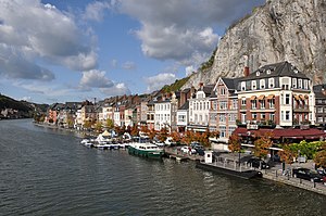
 The Meuse at Dinant | |
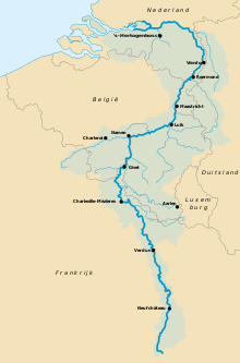
 Basin of the Meuse | |
| Location | |
| Country | France, Belgium, Netherlands |
| Region | Western Europe |
| Cities | Verdun (France), Sedan (France), Charleville-Mézières (France), Namur (Belgium), Liège (Belgium), Maastricht (Netherlands), Venlo (Netherlands), Rotterdam (Netherlands) |
| Physical characteristics | |
| Source | |
| - location | Pouilly-en-Bassigny, Le Châtelet-sur-Meuse, Haute-Marne, Grand Est, France |
| - coordinates | 47°59′12″N 5°37′00″E / 47.9867°N 5.6167°E |
| - elevation | 409 m (1,342 ft) |
| Mouth | North Sea |
| - location | Hollands Diep, Noord-Brabant/Zuid-Holland, Netherlands |
| - coordinates | 51°42′54″N 4°40′04″E / 51.715°N 4.6678°E |
| - elevation | 0 m (0 ft) |
| Length | 925 km (575 mi) |
| Basin size | 34,548 km2 (13,339 sq mi) |
| Discharge | |
| - average | 350 m3/s (12,000 cu ft/s) |
| [1] | |
The Meuse (Dutch: Maas) is a river in Western Europe. The river starts in France, goes through Belgium and the Netherlands. It ends in the North Sea.[2] The Meuse is fed mostly by rainwater.[3] It is the oldest river in the world.
History
From 1301, the Meuse in the Netherlands was the western border of the Holy Roman Empire. In World War II, the Meuse was a goal for the Germans during the Battle of the Bulge.[4]
References
- ↑ Marcel de Wit, Robert Leander, Adri Buishand: Extreme discharges in the Meuse basin Archived 2014-01-06 at the Wayback Machine, p. 2
(The frequently mentioned figure of 250 m³/s refers to the Borgharen gauge near the frontier between Belgium and the Netherlands representing two thirds of the basin.) - ↑ Robert Pateman; Mark Elliott, Belgium (New York: Marshall Cavendish Benchmark, 2006), p. 11
- ↑ Wetlands: Environmental Gradients, Boundaries, and Buffers, ed. George Mulamoottil; et al. (CRC Press, 1996), p. 92
- ↑ Steve Kane, The 1st SS Panzer Division in the Battle of the Bulge (Bennington, VT: Merriam Press, 1997), p. 22