Mount Everest
| Mount Everest | |
|---|---|
 | |
| Highest point | |
| Elevation | 8,848.86 m (29,031.7 ft) Ranked 1st |
| Prominence | 8,848.86 m (29,031.7 ft) Ranked 1st (Special definition for Everest) |
| Isolation | n/a |
| Listing |
|
| Coordinates | 27°59′18″N 86°55′31″E / 27.98833°N 86.92528°E[1] |
| Naming | |
| Etymology | George Everest |
| Native name | |
| English translation | Holy Mother, Skyhead |
| Geography | |
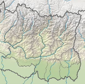
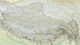
Location on the border between Koshi Province, Nepal and Tibet Autonomous Region, China | |
| Location | Solukhumbu District, Koshi Province, Nepal;[2] Tingri County, Xigazê, Tibet Autonomous Region, China[note 2] |
| Countries | China and Nepal |
| Parent range | Mahalangur Himal, Himalayas |
| Climbing | |
| First ascent | 29 May 1953 Edmund Hillary and Tenzing Norgay [note 3] Ranked 1st |
| Normal route | Southeast ridge (Nepal) |
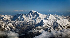
Mount Everest[a] is the highest mountain on Earth. Mount Everest is in the Himalayas, a tall mountain range in Asia.[3] It is about 8,848 metres (29,029 feet) high.[4] Everest is located in Mahalangur Himal sub-range of the Himalayas in the Solukhumbu district of Nepal.
Mount Everest is on the line between two countries: Nepal and China. The top of the mountain is in the "death zone" where the air is too thin for a human to live. People need large bottles of oxygen to let them breathe. The first people to get to the top were Edmund Hillary and Tenzing Norgay in 1953.
There are 18 ways (paths or routes) to get to the top,[5] but most people use only two ways.
History
The Sherpa people live near the bottom of Mount Everest. Mount Everest is important in their religion, and they call the mountain Chomolungma (mother of the earth).[6]

In 1856, the British people made a map of India and measured the height of Mount Everest. They recorded the mountain at 8,840 metres (29,000 feet) and called it Peak XV (Peak Fifteen). In 1865, a group of people in England, the Royal Geographical Society, made a decision to name the mountain Mount Everest.
British people came to the area around Mount Everest in 1921. In 1922, the first group (expedition) tried to go up the mountain. In 1924, a famous English man named George Leigh Mallory and his partner Andrew Irvine tried to get to the top of Mount Everest. They disappeared on June 8th and died. Their bodies were found in 1999.
In May 1953, the first people got to the top. They were a Sherpa man named Tenzing Norgay and a man from New Zealand named Edmund Hillary.
Now, many people go up the mountain every year. They start in China or in Nepal. Sometimes, a country will stop people from going up the mountain. In 2020, Nepal stopped people from going up Mount Everest because people were getting ill from the coronavirus (during the 2019–20 coronavirus pandemic).[7][8]
Sherpa people

The Sherpa people live high in Nepal near the mountain. Because the mountain is important in their religion, a Sherpa person will give something to the gods before they go up the mountain.[9]
Some Sherpas work to help other people go up the mountain. In the spring, they look for the safest way through the rock and ice to go to the top. They take things like food, water, and bottles of air (oxygen) up the mountain.
Everest Base Camps

Base camps are at the bottom ("base") of the mountain. There are two base camps on opposite sides of the mountain: the South Base Camp in Nepal at 5,364 metres (17,598 ft) and the North Base Camp in Tibet, China at 5,150.00 meters (16,896.33 ft) high.[10][11][12] The camps are simple places for people to rest, sleep, or eat when they go up and down the mountain. People often rest at the camps for about a week before they go up Mount Everest. Resting lets the body become comfortable with the thin air, so people do not become very ill with altitude sickness.
The base camps have supplies like food or water. People (usually Sherpas) or large animals like yaks take supplies to the South Base Camp in Nepal. There is a road to the North Base Camp in China, so automobiles can take supplies there in the summer.
The South Base Camp (28°0′26″N 86°51′34″E / 28.00722°N 86.85944°E) is used when climbing up the southeast ridge. The North Base Camp (28°8′29″N 86°51′5″E / 28.14139°N 86.85139°E) is used when climbing up the northeast ridge.[13]
Weather

Mount Everest is very cold and snowy. Winds can be 285 km/h (177 mph). The coldest month is January with a high of −59 °C (−74 °F) and the warmest month is July with a high of −23 °C (−9 °F). Because the Earth is getting warmer from climate change, the ice (glaciers) around Mount Everest may be gone by the year 2100.[14]
| Climate data for Mount Everest | |||||||||||||
|---|---|---|---|---|---|---|---|---|---|---|---|---|---|
| Month | Jan | Feb | Mar | Apr | May | Jun | Jul | Aug | Sep | Oct | Nov | Dec | Year |
| Daily mean °C (°F) | −36 (−33) |
−35 (−31) |
−32 (−26) |
−31 (−24) |
−25 (−13) |
−20 (−4) |
−18 (0) |
−18 (0) |
−21 (−6) |
−27 (−17) |
−30 (−22) |
−34 (−29) |
−27 (−17) |
| Source: [15] | |||||||||||||
Other mountain climbing records

In 2024, a climber, Kami Rita Sherpa became the first to get to the top of the mountain 30 times.[16] Earlier (2023), Kami Rita became the first to get to the top of the mountain 27 times.[17] Phunjo Lama is the women with "Fastest women to climb Mount Everest" record. She climbed Everest in 2024, May 22 in 24 hours and 26 minutes. [18]
Other mountains
Most people say that Mount Everest is the highest mountain, because it is 8,848 metres (29,029 feet) high from sea level. But, two other mountains can be named the "highest" mountains.

One is Mauna Loa, which is a tall volcano on the Hawaiian Islands. Mauna Loa is 4,169 metres (13,678 feet) high from sea level. But the bottom of Mauna Loa is deep underwater, and from the bottom to the top it is about 17 kilometres (56,000 feet). Some people say that Mauna Loa is the "tallest" mountain, not the "highest" mountain.
Another is Mount Chimborazo, which is a tall mountain in South America. The top of Mount Chimbroazo is the farthest from the center of the Earth. This is because of the shape of the Earth: the Earth is wider at the Equator than at the poles (North Pole and South Pole).
Notes
Notes
- ↑ Based on the 2020 surveys of elevation of snow cap, not rock head. For more details, see Surveys[broken anchor].
- ↑ The position of the summit of Everest on the international border is clearly shown on detailed topographic mapping, including official Nepali mapping.
- ↑ It remains unclear whether George Mallory and Andrew Irvine reached the summit in 1924 or not. For more details, see 1924 British Mount Everest expedition.
References
- ↑ "Mount Everest". Peakbagger.com.
- ↑ Geography of Nepal: Physical, Economic, Cultural and Regional by Netra Bahadur Thapa, D. P. Thapa Orient Longmans, 1969.
- ↑ Discover, Altitude. "Mount Everest".
- ↑ Brooks, David (2008-01-11). "Edmund Hillary, first atop Everest, dead at 88". Sydney Morning Herald. Retrieved 2009-09-14.
- ↑ https://www.nationalgeographic.com/travel/article/150420-everest-climbing-sherpas-mountaineering-nepal-himalayas-guides. National Geographic (2015)
- ↑ Bashyal, Pradeep (8 June 2019). "Everest through the eyes of a Sherpa: 'Climbers need to wake up'". BBC News. BBC. Retrieved 22 December 2022.
- ↑ "Mount Everest closes because of virus outbreak". BBC News. 13 March 2020. Retrieved 20 March 2020.
- ↑ Young, Emile (16 March 2020). "The Everest Closure in Numbers: How the Sherpa Are Affected". Rock and Ice. Archived from the original on 20 March 2020. Retrieved 20 March 2020.
- ↑ "Geology: legends of fairies and dragons (Mountain goddess of Mount Everest)" (in German). Online Focus. Retrieved 3 March 2016.
- ↑ Foster, Simon; Jen Lin-Liu; Sherisse Pham; Sharon Owyang; Beth Reiber; Lee Wing-Sze; Christoper D. Winnan (2010). Frommer's China. John Wiley & Sons, 2010. p. 5. ISBN 9780470526583. Retrieved 2012-04-03.
- ↑ Reynolds, Kev (2006). Everest - A trekker's guide. Cicerone Press Limited. p. 231. ISBN 978-1-84965-076-2. Retrieved 2012-04-03.
- ↑ Buckley, Michael (2008). Shangri-La: A Travel Guide to the Himalayan Dream. Bradt Travel Guides. p. 165. ISBN 9781841622040. Retrieved 2012-04-03.
- ↑ Mayhew, Bradley; Bindloss, Joe (2009). Trekking in the Nepal Himalaya. Lonely Planet. ISBN 978-1741041880. Retrieved 2012-03-10.
- ↑ "Most glaciers in Mount Everest area will disappear with climate change – study". The Guardian. 27 May 2015. Retrieved 16 August 2015.
- ↑ "Monthly Average Coldest temperature on Everest Summit". topchinatravel.com/. Retrieved 16 August 2015.
- ↑ https://www.vg.no/sport/i/rPgp5w/kami-rita-sherpa-har-vaert-30-ganger-paa-toppen-av-mount-everest. Retrieved 2024-05-22
- ↑ https://kathmandupost.com/money/2023/05/17/kami-rita-sherpa-breaks-his-own-record-climbs-everest-for-27th-time. Kathmandy Post. Retrieved 2023-05-17
- ↑ Himalayan, Masters (2023). "Everest 2024".


