Natural regions of Germany
 Major natural regions in Germany

Regions
Northeast German Plain
- D01 Mecklenburg Coastal Lowland[1] (71)
- D02 Northeast Mecklenburg Lowland (including the Szczecin Lagoon) (72-73)
- Northeast Mecklenburg Lowland (72, northwest and centre)
- Szczecin Lagoon (73 east)
- D03 Mecklenburg Lake Plateau Hinterland (74)
- D04 Mecklenburg Lake Plateau[1] (75)
- D05 Mecklenburg-Brandenburg Plateau and Upland (76-78)
- Southwest Foreland of the Mecklenburg Lake Plateau (76, northwest)
- North Brandenburg Plateau and Upland (77, centre)
- Luchland (78, southeast)
- D06 East Brandenburg Plateau (79)
- D07 Oder Valley (80)
- D08 Lusatian Basin and Spreewald[1] (83-84)
- Spreewald (83, northeast)
- Lusatian Basin and Lower Lusatian Heath[1] (84, centre, west and south)
- D09 Middle Elbe Plain[2] (87)
- D10 Elbe-Mulde Plain (88)
- D11 Fläming Heath[1][2] (85)
- D12 Brandenburg Heath and Lake District (81-82)
- Central Brandenburg Plateaux and Lowland (81, west)
- East Brandenburg Heath and Lake District (82, east)
- D13 Upper Lusatian Plateau[1] (89)
- Saxon Lowland*[2] (new overarching region/division)
- D19 Saxon Upland and Ore Mountain Foreland[1] (45-46)
- Ore Mountain Foreland (45, south)
- Saxon Upland[1] (including Leipziger Land) (46, west, north and east)
- D14 Upper Lusatia[1][2] (44) - excluding the Lusatian Upland (441)
- D20 Eastern Harz Foreland and Börde (50)
- D29 Wendland and Altmark[2] (86)

Northwest German Plain
- D21 Schleswig-Holstein Marsch[2] (68)
- D22 Schleswig-Holstein Geest[1][2] (69)
- D23 Schleswig-Holstein Uplands[2] (70)
- D24 Lower Elbe Marsch[2] (67)
- D25 Ems and Weser Marsch (61)
- D26 East Frisian Geest[2] (60)
- D27 Stade Geest[2] (63)
- D28 Lüneburg Heath[1][2] (64)
- D30 Dümmer and Ems-Hunte Geest (58-59)
- Dümmer Geest Lowland (58, south)
- Ems-Hunte Geest[2] (59, north)
- D31 Weser-Aller Plain (62)
- D32 Lower Saxony Börde[2] (52)
- D33 North Harz Foreland[2] (51)
- D34 Westphalian Lowland[2] or Basin[1] (Münster Lowland) (54)
- D35 Lower Rhine Plain[2] and Cologne Lowland[1][2] (55, 57)
- Cologne Lowland[1][2] (55, south)
- Lower Rhine Plain[2] (57, north)

Western Central Uplands
- D36 Lower Saxon Hills[1] (including the Weser[2] and Leine Uplands[2]) (36-37, 53)
- Lower Weser Uplands (53, northwest)
- Upper Weser Uplands (36, centre)
- Leine Uplands[2] (37, east)
- D37 Harz[2] (38)
- D38 Sauerland (Süderbergland)[1][2] (33)
- D39 Westerwald[1][2] (32)
- D40 Gießen-Koblenz Lahn Valley (31)
- D41 Taunus[1][2] (30)
- D42 Hunsrück[1][2] (24)
- D43 Moselle Valley[2] (25)
- D44 Middle Rhine[1] (including Siebengebirge) (29)
- D45 Eifel[1][2] (including Venn Foreland) (27-28, 56)
- East Eifel (27, east and centre)
- West Eifel (28, west)
- Venn Foreland (56, extreme northwest)
- D46 West Hesse Highlands (34)
- D47 East Hesse Highlands (35)
- D49 Bitburg Land[1][2] (Gutland) (26)
- D50 Palatine-Saar Muschelkalk Region (18)
- D51 Palatinate Forest[1] (the Haardt[2]) (17)
- D52 Saar-Nahe Hills[1] or Upland[2] (19)
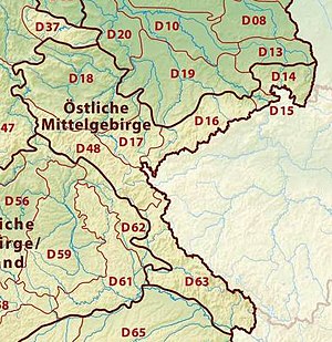
Eastern Central Uplands
- Saxon Highlands and Uplands* (new supra-region)
- D14 Upper Lusatia[2] (44) -
- only 441 Upper Lusatian Plateau[1]
- D15 Saxon-Bohemian Chalk Sandstone Region (43)
- D16 Ore Mountains[1] (Erzgebirge) (42)
- D17 Vogtland[1][2] (41)
- D18 Thuringian Basin including outer plateaus (47-48)
- Southern plateau of the Thuringian Basin (47, south)
- Thuringian Basin[1] (48; north, west and centre)
- D48 Thuringian-Franconian Upland (39)
- D63 Upper Palatine-Bavarian Forest (40)
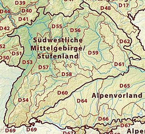
South German Scarplands[1][2]
- D53 Upper Rhine Plain[1][2] (20-23)
- Southern Upper Rhine Plain (20, extreme south)
- Middle Upper Rhine Plain (21, south of centre)
- Northern Upper Rhine Plain (22, centre and north)
- Rhine-Main Lowland[1] (23, northeast)
- D54 Black Forest[1][2] (15)
- D55 Odenwald,[1][2] Spessart[1][2] and South Rhön (14)
- D56 Mainfranken Plateau (13)
- D57 Gäu Plateaus[1] (12)
- D58 Swabian Keuper-Lias Plains[2] (10)
- D59 Franconian Keuper-Lias Plains[2] (11)
- D60 Swabian Jura[1][2] (09)
- D61 Franconian Jura[1][2] (08)
- D62 Upper Palatinate-Upper Main Hills (07)
- D69 Dinkelberg and Upper Rhine Valley (16)

Alpine Foreland[1] and Alps
- D64 Iller-Lech Plateau[2] (04)
- D65 Lower Bavarian Uplands and Isar-Inn Gravel Plateau (05-06)
- Isar-Inn Gravel Plateau (05, Süden)
- Lower Bavarian Uplands[2] (06, Mitte und Norden)
- D66 Southern Alpine Foreland (03)
- D67 Swabian-Bavarian Foreland (02)
- D68 Northern Limestone Alps (01)
North and Baltic Seas
References
- ↑ 1.00 1.01 1.02 1.03 1.04 1.05 1.06 1.07 1.08 1.09 1.10 1.11 1.12 1.13 1.14 1.15 1.16 1.17 1.18 1.19 1.20 1.21 1.22 1.23 1.24 1.25 1.26 1.27 1.28 1.29 1.30 1.31 1.32 1.33 1.34 1.35 1.36 1.37 Elkins (1972).
- ↑ 2.00 2.01 2.02 2.03 2.04 2.05 2.06 2.07 2.08 2.09 2.10 2.11 2.12 2.13 2.14 2.15 2.16 2.17 2.18 2.19 2.20 2.21 2.22 2.23 2.24 2.25 2.26 2.27 2.28 2.29 2.30 2.31 2.32 2.33 2.34 2.35 2.36 2.37 2.38 2.39 2.40 2.41 2.42 2.43 2.44 2.45 Dickinson (1964).


