Nièvre (Loire)
| Nièvre | |
|---|---|
 | |
 | |
| Location | |
| Country | France |
| Physical characteristics | |
| Source | |
| - location | Burgundy |
| Mouth | |
| - location | Loire |
| - coordinates | 46°59′5″N 3°9′32″E / 46.98472°N 3.15889°E |
| Length | 49.6 km (30.8 mi) |
| Basin features | |
| Progression | Loire→ Atlantic Ocean |
The Nièvre is a small river in France, right tributary of the Loire river. It flows through the Nièvre department in the Bourgogne-Franche-Comté region.
Two communes of the Nièvre department have the name of the river in their names: Dompierre-sur-Nièvre and La Celle-sur-Nièvre.
Geography
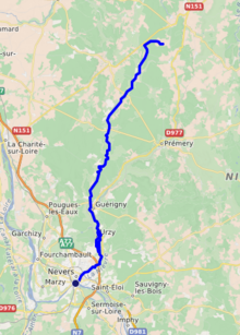
The Nièvre river has a length of 49.6 km (30.8 mi) and a drainage basin with an area of 630 km2 (243 sq mi).[1]
Its average yearly discharge (volume of water which passes through a section of the river per unit of time) is 5.28 cubic metres per second at Uzy.[2]
Course
The source of the Nièvre is near the village Bourras-la-Grange in the Champlemy commune, Nièvre department, at an altitude of about 280 m (919 ft).[3]
The Nièvre flows, in general, from the northeast to the southwest and passes through the following cantons and communes, all in the Nièvre department:[1]
- Cantons: Prémery, Donzy, La Charité-sur-Loire, Pougues-les-Eaux, Guérigny and Nevers-Nord.
- Communes: Champlemy, Saint-Malo-en-Donziois, Châteauneuf-Val-de-Bargis, Dompierre-sur-Nièvre, La Celle-sur-Nièvre, Beaumont-la-Ferrière, Saint-Aubin-les-Forges, Parigny-les-Vaux, Guérigny, Urzy, Saint-Martin-d'Heuille, Coulanges-lès-Nevers, Nevers
Finally, it flows, as a right tributary into the Loire River in the centre of the city of Nevers, at 170 m (558 ft) of altitude.[4]
Main tributaries
The main tributaries of the Nièvre are (only right tributaries because the left tributaries are very short):
Gallery
The Nièvre river flowing through downtown Nevers before joining the Loire river:


Related pages
References
- ↑ 1.0 1.1 "La Nièvre (K19-0300)" (in French). SANDRE - Portail national d'accès aux référentiels sur l'eau. Archived from the original on 3 March 2016. Retrieved 9 October 2014.
- ↑ "La Nièvre à Urzy (K1963010)" (in French). Banque Hydro. Archived from the original on 24 September 2015. Retrieved 9 October 2014.
- ↑ "Source de la Nièvre" (in French). Géoportail. Retrieved 9 October 2014.
- ↑ "Confluence de la Nièvre" (in French). Géoportail. Retrieved 9 October 2014.
- ↑ "La Nièvre de Champlémy (K1944500)" (in French). SANDRE - Portail national d'accès aux référentiels sur l'eau. Archived from the original on 2 February 2015. Retrieved 9 October 2014.
- ↑ "La Nièvre d'Arzembouy (K1954000)" (in French). SANDRE - Portail national d'accès aux référentiels sur l'eau. Archived from the original on 27 December 2014. Retrieved 9 October 2014.
Other websites
- Banque Hydro - Station K1963010 - La Nièvre à Urzy (Synthèse) Archived 2016-03-03 at the Wayback Machine (in French)