North Kingstown, Rhode Island
North Kingstown, Rhode Island | |
|---|---|
 The Gilbert Stuart Birthplace in North Kingstown | |
| Nickname: "NK" | |
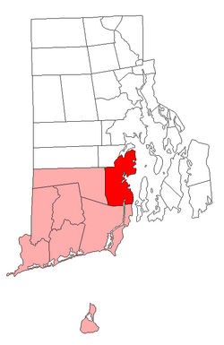
 Location of North Kingstown in Washington County, Rhode Island | |
| Coordinates: 41°34′50″N 71°27′14″W / 41.58056°N 71.45389°W | |
| Country | United States |
| State | Rhode Island |
| County | Washington |
| Area | |
| • Total | 58.3 sq mi (151.1 km2) |
| • Land | 43.6 sq mi (112.9 km2) |
| • Water | 14.7 sq mi (38.2 km2) |
| Elevation | 82 ft (25 m) |
| Population (2020)[1] | |
| • Total | 27,732 |
| • Density | 636/sq mi (245.6/km2) |
| Time zone | UTC−5 (Eastern (EST)) |
| • Summer (DST) | UTC−4 (EDT) |
| ZIP codes | 02852 (North Kingstown), 02874 (Saunderstown), 02877 (Slocum) |
| Area code | 401 |
| FIPS code | 44-51580[2] |
| GNIS feature ID | 1220088[3] |
| Website | www.northkingstown.org |
North Kingstown is a town in Washington County, Rhode Island, United States. It is part of the Providence metropolitan area. The population was 27,732 in the 2020 census.[1]
References
- ↑ 1.0 1.1 "QuickFacts: North Kingstown town, Washington County, Rhode Island". U.S. Census Bureau. Retrieved August 3, 2023.
- ↑ "U.S. Census website". United States Census Bureau. Retrieved 2008-01-31.
- ↑ "US Board on Geographic Names". United States Geological Survey. 2007-10-25. Retrieved 2008-01-31.
