Oirschot
Oirschot | |
|---|---|
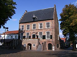 Former city hall of Oirschot | |
 Flag Coat of arms | |
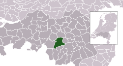 Location in North Brabant | |
| Coordinates: 51°30′N 5°18′E / 51.500°N 5.300°E | |
| Country | |
| Province | |
| Government | |
| • Body | Municipal council |
| • Mayor | Judith Keijzers-Verschelling (CDA) |
| Area | |
| • Total | 102.84 km2 (39.71 sq mi) |
| • Land | 101.78 km2 (39.30 sq mi) |
| • Water | 1.06 km2 (0.41 sq mi) |
| Elevation | 17 m (56 ft) |
| Population (January 2019)[4] | |
| • Total | 18,623 |
| • Density | 183/km2 (470/sq mi) |
| Demonym | Oirschottenaar |
| Time zone | UTC+1 (CET) |
| • Summer (DST) | UTC+2 (CEST) |
| Postcode | 5090–5091, 5688–5689 |
| Area code | 013, 0499 |
| Website | www |
Oirschot is a municipality in the Dutch province of North Brabant. In 2019, 18,623 people lived there.
References
- ↑ "Samenstelling" [Members] (in Dutch). Gemeente Oirschot. Archived from the original on 14 July 2014. Retrieved 2 June 2014.
- ↑ "Kerncijfers wijken en buurten 2020" [Key figures for neighbourhoods 2020]. StatLine (in Dutch). CBS. 24 July 2020. Retrieved 19 September 2020.
- ↑ "Postcodetool for 5688AK". Actueel Hoogtebestand Nederland (in Dutch). Het Waterschapshuis. Retrieved 2 June 2014.
- ↑ "Bevolkingsontwikkeling; regio per maand" [Population growth; regions per month]. CBS Statline (in Dutch). CBS. 1 January 2019. Retrieved 1 January 2019.
