Orcières
Orcières | |
|---|---|
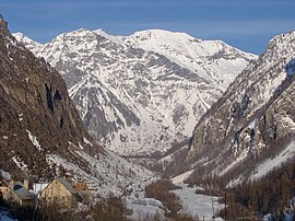 Valley of Prapic | |
 Coat of arms | |
 Orcières  Orcières | |
| Coordinates: 44°41′07″N 6°19′33″E / 44.6853°N 6.3258°E | |
| Country | France |
| Region | Provence-Alpes-Côte d'Azur |
| Department | Hautes-Alpes |
| Arrondissement | Gap |
| Canton | Saint-Bonnet-en-Champsaur |
| Intercommunality | Haut Champsaur |
| Government | |
| • Mayor (2008–2014) | Patrick Ricou |
| Area 1 | 98.27 km2 (37.94 sq mi) |
| Population (Jan. 2019)[1] | 674 |
| • Density | 6.9/km2 (18/sq mi) |
| Time zone | UTC+01:00 (CET) |
| • Summer (DST) | UTC+02:00 (CEST) |
| INSEE/Postal code | 05096 /05170 |
| Elevation | 1,174–3,117 m (3,852–10,226 ft) (avg. 1,439 m or 4,721 ft) |
| 1 French Land Register data, which excludes lakes, ponds, glaciers > 1 km2 (0.386 sq mi or 247 acres) and river estuaries. | |
Orcières is a commune in the Hautes-Alpes department.
Population
| Year | Pop. | ±% |
|---|---|---|
| 1962 | 514 | — |
| 1968 | 734 | +42.8% |
| 1975 | 855 | +16.5% |
| 1982 | 890 | +4.1% |
| 1990 | 841 | −5.5% |
| 1999 | 810 | −3.7% |
| 2008 | 700 | −13.6% |
Transport
Road
The D76, D474, D475 and D944 roads pass through the commune of Orcières.
Ski resort
The commune has a ski resort called Orcières-Merlette.[2]
Geography
Orcières is on the edge of the Écrins National Park. It is also around 10 miles away from the border with the Isere department and 23 miles away from the border with the France-Italy border.
References
- ↑ "Populations légales 2019". The National Institute of Statistics and Economic Studies. 29 December 2021.
- ↑ d'Orcières, Office de tourisme (2018-12-28). "Station de ski des Hautes-Alpes". Orcières Merlette 1850 (in French). Retrieved 2021-01-16.