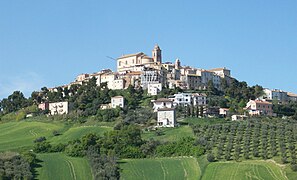
Province of Ascoli Piceno
Province of Ascoli Piceno | |
|---|---|
 Palazzo del Governo in Ascoli Piceno, the provincial seat. | |
 Map highlighting, in red, the province of Ascoli Piceno in Italy | |
| Coordinates: 42°51′17″N 13°34′31″E / 42.85472°N 13.57528°E | |
| Country | Italy |
| Region | Marche |
| Capital | Ascoli Piceno |
| Comuni | 33 |
| Government | |
| • President | Paolo D'Erasmo[1] |
| Area | |
| • Total | 1,228.27 km2 (474.24 sq mi) |
| Population (1 November 2017)[3] | |
| • Total | 209,450 |
| • Density | 170/km2 (440/sq mi) |
| Time zone | UTC+1 (CET) |
| • Summer (DST) | UTC+2 (CEST) |
| Postal code | 63100 |
| Telephone prefix | 0736 |
| Vehicle registration | MC |
| ISTAT | 044 |
| Website | Official website |
The Province of Ascoli Piceno (Italian: Provincia di Ascoli Piceno) is a province in the region of Marche in Italy. Its capital is the city of Ascoli Piceno.
Geography

Ascoli Piceno has an area of 1,228.27 km2 (474 sq mi).[4] The province is bordered to the east by the Adriatic Sea and to the north with the provinces of Macerata and Fermo. It borders with three regionsː the Abruzzo region to the south, the Lazio region to the soutwest and the Umbria region to the west.
The main river in the province is Tronto, 115 km (71.5 mi) long and the highest mountain is Monte Vettore (42°49′28″N 13°16′30″E / 42.82444°N 13.27500°E), with an altitude of 2,476 m (8,123 ft).[5]
Population
There are 209,450 persons living in the province (1 January 2017).[3] The population density was 170.5 inhabitants/km².
Evolution of the population

Municipalities
There are 33 municipalities (or comuni) in the province; they are:
- Acquasanta Terme
- Acquaviva Picena
- Appignano del Tronto
- Arquata del Tronto
- Ascoli Piceno
- Carassai
- Castel di Lama
- Castignano
- Castorano
- Colli del Tronto
- Comunanza
- Cossignano
- Cupra Marittima
- Folignano
- Force
- Grottammare
- Maltignano
- Massignano
- Monsampolo del Tronto
- Montalto delle Marche
- Montedinove
- Montefiore dell'Aso
- Montegallo
- Montemonaco
- Monteprandone
- Offida
- Palmiano
- Ripatransone
- Roccafluvione
- Rotella
- San Benedetto del Tronto
- Spinetoli
- Venarotta
The largest comune is Ascoli Piceno, with 158.02 km2 (61 sq mi) and the smallest is Colli del Tronto, with 5.94 km2 (2 sq mi). The comune with fewest inhabitants is Palmiano, with 188 inhabitants.
Main comuni
The following table shows the 10 comuni with more inhabitants with their population,[3] and their area and altitude.[6]
| No. | Comune | Population (2017) |
Area (km²) |
Density | Altitude (m) |
|---|---|---|---|---|---|
| 1 | Ascoli Piceno | 49,203 | 158.02 | 311.4 | 154 |
| 2 | San Benedetto del Tronto | 47,420 | 18.00 | 2,634.4 | 4 |
| 3 | Grottammare | 16,139 | 158.02 | 102.1 | 4 |
| 4 | Monteprandone | 12,602 | 26.38 | 477.7 | 273 |
| 5 | Folignano | 9,261 | 14.86 | 623.2 | 319 |
| 6 | Castel di Lama | 8,613 | 10.98 | 784.4 | 201 |
| 7 | Spinetoli | 7,221 | 12.58 | 574.0 | 177 |
| 8 | Cupra Marittima | 5,391 | 17.34 | 310.9 | 4 |
| 9 | Offida | 5,008 | 49.60 | 101.0 | 293 |
| 10 | Monsampolo del Tronto | 4,515 | 15.43 | 292.6 | 158 |
Gallery
-
Piazza del Popolo, Ascoli Piceno.
-
Grottammare.
-
Monteprandone.
Related pages
References
- ↑ "Presidente" (in Italian). Provincia di Ascoli Piceno. 29 June 2011. Retrieved 28 June 2016.
- ↑ "Provincia di Ascoli Piceno" (in Italian). Tuttitalia.it. Retrieved 28 June 2016.
- ↑ 3.0 3.1 3.2 "Statistiche demografiche ISTAT" (in Italian). Demo.istat.it. Archived from the original on 13 February 2021. Retrieved 28 June 2016.
- ↑ "Territorio" (in Italian). Provincia di Ascoli Piceno. 30 March 2012. Retrieved 28 June 2016.
- ↑ "Monte Vettore, Italy". Peakbagger.com. Retrieved 30 June 2017.
- ↑ "Comuni in provincia di Ascoli Piceno per popolazione" (in Italian). Tuttitalia.it. Retrieved 30 June 2017.
Other websites
- Province of Ascoli Piceno official website (in Italian)


