Republika Srpska
Republika Srpska Република Српска | |
|---|---|
 Flag
 Seal
| |
| Anthem: Моја Република[1] Moja Republika My Republic | |
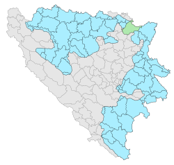 Location of the Republika Srpska (blue) and Brčko District (green) within Bosnia and Herzegovina.a | |
| Capital | Sarajevo[2] (de jure) Banja Luka (de facto; administrative centre) |
| Largest city | Banja Luka |
| Official languages | Serbian, Bosnian and Croatianb |
| Ethnic groups (2013 census[3]) | |
| Government | Parliamentary system |
| Milorad Dodik | |
| Radovan Višković | |
| Legislature | National Assembly |
| Formation | |
• Proclaimed | 9 January 1992 |
• Recognized as part of Bosniaand Herzegovina | 14 December 1995 |
| Area | |
• Total | 24,525.5 km2 (9,469.3 sq mi) |
• Water (%) | n/a |
| Population | |
• 2013 census | 1,218,107 d |
• Density | 53/km2 (137.3/sq mi) |
| Currency | Republika Srpska dinar (1992-1994) Yugoslav dinar (1994-1998) convertible mark (1998-present) (BAM) |
| Time zone | UTC+1 (CET) |
• Summer (DST) | UTC+2 (CEST) |
| Calling code | +387 |
| ISO 3166 code | BA-SRP |
| |
Republika Srpska (Serbo-Croatian: Република Српска / Republika Srpska) is one of the two parts of Bosnia and Herzegovina. The other part is the Federation of Bosnia and Herzegovina, and there is also a special city that is not in either, the Brčko District.

Regions
The Republika Srpska has seven main parts (called regions). They are:
| Region | Municipalities | Comments | |
|---|---|---|---|
| 1. | Banja Luka | Banja Luka (City status), Čelinac, Gradiška, Istočni Drvar, Jezero, Kneževo, Kostajnica, Kotor Varoš, Kozarska Dubica, Krupa na Uni, Kupres, Laktaši, Mrkonjić Grad, Novi Grad, Oštra Luka, Petrovac, Prijedor (City status), Ribnik, Srbac, Šipovo, Teslić | |
| 2. | Doboj | Brod, Derventa, Doboj (City status), Donji Žabar, Modriča, Pelagićevo, Petrovo, Prnjavor, Stanari, Šamac, Vukosavlje | |
| 3. | Bijeljina | Bijeljina (City status), Lopare, Ugljevik | |
| 4. | Vlasenica | Bratunac, Milići, Osmaci, Srebrenica, Šekovići, Vlasenica, Zvornik (City status) | |
| 5. | Sarajevo-Romanija or Sokolac | Han Pijesak, Istočna Ilidža, Istočno Novo Sarajevo, Istočni Stari Grad, Istočno Sarajevo (City status), Pale, Rogatica, Sokolac, Trnovo | |
| 6. | Foča | Čajniče, Foča, Kalinovik, Novo Goražde or Ustiprača, Rudo, Višegrad | |
| 7. | Trebinje | Berkovići, Bileća, Gacko, Istočni Mostar, Ljubinje, Nevesinje, Trebinje (City status) | |
| Brčko District | Brčko District is place controlled by Bosnia and Herzegovina instead. |
Related pages
References
- ↑ (in Serbian) v1-857c-516c55d5841d&page_id=7 Srpska – Portal javne uprave Republike Srpske: Simboli at the Government of Republika Srpska official website (retrieved 17 May 2012).
- ↑ "Constitution of the Republika Srpska-Official Web Site of the Office of the High Representative".
- ↑ Sarajevo, juni 2016. CENZUS OF POPULATION, HOUSEHOLDS AND DWELLINGS IN REPUBLIKA SRPSKA, 2013 FINAL RESULTS. BHAS. Archived from the original on 1 January 2017. Retrieved 30 June 2016.
- ↑ "Decision on Constitutional Amendments in Republika Srpska". Office of the High Representative. Archived from the original on 25 December 2018. Retrieved 3 June 2010.
- ↑ (in Serbian) Constitution of Republika Srpska Archived 2012-02-12 at the Wayback Machine
Other websites
![]() Media related to Republika Srpska at Wikimedia Commons
Media related to Republika Srpska at Wikimedia Commons
| International | |
|---|---|
| National | |
| Geographic | |
| Other | |