River Great Ouse
| River Great Ouse | |
|---|---|
 The River Great Ouse after Brownshill Staunch, near Over in Cambridgeshire | |
 Great Ouse catchment | |
| Location | |
| Country | United Kingdom |
| Constituent country | England |
| Counties | Northamptonshire, Buckinghamshire, Bedfordshire, Cambridgeshire, Norfolk |
| Physical characteristics | |
| Source | |
| - location | Syresham, South Northamptonshire, Northamptonshire, England |
| - coordinates | 52°05′33″N 1°05′35″W / 52.09252°N 1.09301°W |
| - elevation | 150 m (490 ft) |
| Mouth | The Wash |
| - location | King's Lynn, United Kingdom |
| - coordinates | 52°47′47″N 0°21′53″E / 52.79632°N 0.36468°E |
| - elevation | 0 m (0 ft) |
| Length | 230 km (143 mi) |
| Basin size | 8,380 km2 (3,240 sq mi) |
| Discharge | |
| - location | Denver Sluice [1] Catchment area 3430 km2 |
| - average | 15.8 m3/s (560 cu ft/s)Catchment area 3430 km2 |
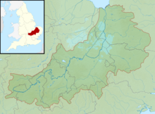
The River Great Ouse (/ˈuːz/) is a river in the England. It is the longest of several British rivers called "Ouse".
From Syresham in central England, the Great Ouse flows into East Anglia. It goes into the Wash, a bay of the North Sea.
Its course is 143 miles (230 km), mostly flowing north and east.[2] It is the fifth longest river in the United Kingdom. The Great Ouse was important for commercial navigation, and for draining the low-lying region through which it flows.
Its best-known tributary is the Cam, which runs through Cambridge. Its lower course passes through drained wetlands and fens. It has been extensively modified to relieve flooding and provide a better route for barge traffic. It now enters the Wash after passing through the port of King's Lynn.
Other rivers called the Ouse
River Ouse, Yorkshire River Ouse, Sussex River Great Ouse, Northamptonshire and East Anglia River Little Ouse, a tributary of the River Great Ouse There are also some rivers in other countries called the Ouse.
References
- ↑ Ely Ouse at Denver Complex gauging station.
- ↑ Owen, Susan; et al. (2005). Rivers and the British Landscape. Carnegie. ISBN 978-1-85936-120-7.