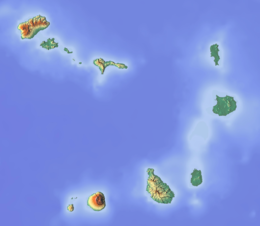
São Nicolau, Cape Verde
| Native name: Saniclau Nickname: Ilha de Chiquinho | |
|---|---|
 | |
| Geography | |
| Location | Atlantic Ocean |
| Coordinates | 16°36′54″N 24°16′16″W / 16.615°N 24.271°W |
| Area | 343 km2 (132 sq mi) |
| Length | 44.5 km (27.65 mi) |
| Width | 22.0 km (13.67 mi) |
| Highest elevation | 1,312 m (4304 ft) |
| Highest point | Monte Gordo |
| Administration | |
| Concelhos (Municipalities) | Ribeira Brava, Tarrafal de São Nicolau |
| Largest settlement | Ribeira Brava |
| Demographics | |
| Population | 12,424[1]:36 (2015) |
| Pop. density | 36.2/km2 (93.8/sq mi) |
São Nicolau is an island of Cape Verde. It is one of the Barlavento group. In 2015, about 12,400 people lived there.[1] The main towns are Ribeira Brava and Tarrafal de São Nicolau.
The island was discovered in 1461 or 1462 by Diogo Afonso, together with the islands of São Vicente and Santo Antão.[2]
References
- ↑ 1.0 1.1 Cabo Verde, Statistical Yearbook 2015, Instituto Nacional de Estatística
- ↑ Valor simbólico do centro histórico da Praia, Lourenço Conceição Gomes, Universidade Portucalense, 2008
Wikimedia Commons has media related to São Nicolau (Cape Verde).
