Shrewsbury, Massachusetts
Town of Shrewsbury | |
|---|---|
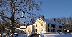 Homestead of General Artemas Ward | |
 Location in Worcester County and the state of Massachusetts. | |
| Coordinates: 42°17′45″N 71°42′48″W / 42.29583°N 71.71333°W | |
| Country | United States |
| State | Massachusetts |
| County | Worcester |
| Settled | 1722 |
| Incorporated | 1727 |
| Government | |
| • Type | Representative town meeting |
| • Town Manager | Kevin Mizikar |
| • Board of Selectmen | James Kane Maurice DePalo Moira Miller John Lebeaux Beth Casavant |
| Area | |
| • Total | 21.7 sq mi (56.1 km2) |
| • Land | 20.7 sq mi (53.7 km2) |
| • Water | 0.9 sq mi (2.4 km2) |
| Elevation | 668 ft (204 m) |
| Population (2010) | |
| • Total | 35,608 |
| • Density | 1,526.3/sq mi (589.3/km2) |
| Time zone | UTC−5 (Eastern) |
| • Summer (DST) | UTC−4 (Eastern) |
| ZIP Code | 01545 |
| Area code | 508 / 774 |
| FIPS code | 69-60165 |
| GNIS feature ID | 0619489 |
| Website | www.shrewsbury-ma.gov |
Shrewsbury is a town in Worcester County, Massachusetts, United States. The population was 35,644 according to the 2010 US Census, in nearly 12,400 households.
Shrewsbury is home to three current and one former Nationally Registered Historic Places:
- The Gen. Artemas Ward Homestead on Main Street
- The Shrewsbury Historic District, in the town center which includes parts of Church Road, Main Street, Prospect Street, Boylston Street, and Grafton Street
- 1767 Milestones, of which two surviving milestones are in town, along the route of the old Boston Post Road.
Other websites
- Town of Shrewsbury Official Website Archived 2015-09-24 at the Wayback Machine
- Commission on Disabilities
- Shrewsbury Historical Society
- Old Shrewsbury Historical Society Page
Municipalities and communities of Worcester County, Massachusetts, United States | ||
|---|---|---|
| Cities |  | |
| Towns |
| |
| CDPs |
| |
| Other villages |
| |
| Ghost town |
| |
| Indian reservations |
| |
| Footnotes | ‡This populated place also has portions in an adjacent county or counties | |