Tallahatchie River
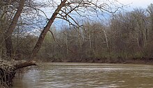

The Tallahatchie River is a river in Mississippi. It flows 230 miles (370 km)[1] from Tippah County, through Tallahatchie County, to Leflore County, where it joins the Yalobusha River to form the Yazoo River.[2][3] The river is navigable for about 100 miles.[4]
References
- ↑ Hopkins, Daniel J., editor (1997). Merriam-Webster's Geographical Dictionary. (Third Edition). Springfield, MA: Merriam-Webster, Inc. Publishers. p.1155.ISBN 0-87779-546-0
- ↑ "The National Map". U.S. Geological Survey. Archived from the original on August 23, 2017. Retrieved Feb 9, 2011.
- ↑ "Tallahatchie River". Geographic Names Information System. United States Geological Survey.
- ↑ Hopkins. Merriam-Webster's Geographical Dictionary.