เซนต์แคเทอรีนส์
เซนต์แคเทอรีนส์ | |
|---|---|
เมือง | |
 From top left: The corner of St. Paul and Queen streets, the Silver Spire United Church on St. Paul, a ship traversing the Welland Canal with the Garden City Skyway in the background, the lighthouse of Port Dalhousie, the Arthur Schmon Tower of Brock University, and the gazebo in Montebello Park | |
| สมญา: The Garden City | |
| คำขวัญ: Industry and Liberality | |
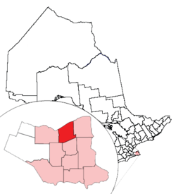
 สถานที่ตั้งในเซนต์แคเทอรีนส์ในรัฐออนแทรีโอ | |
| พิกัด: 43°11′N 79°14′W / 43.183°N 79.233°W | |
| Country | |
| Province | แม่แบบ:ON |
| Region | Niagara |
| Settled | 1783 |
| Incorporated | 1845 (town) |
| 1876 (city) | |
| การปกครอง | |
| • Mayor | Brian McMullan |
| • Governing body | St. Catharines City Council |
| • MPs | Rick Dykstra, Malcolm Allen |
| • MPPs | Jim Bradley, Peter Kormos |
| พื้นที่[1][2][3] | |
| • พื้นดิน | 96.11 ตร.กม. (37.11 ตร.ไมล์) |
| • เขตเมือง | 378.68 ตร.กม. (146.21 ตร.ไมล์) |
| • รวมปริมณฑล | 1,397.51 ตร.กม. (539.58 ตร.ไมล์) |
| ความสูง[4] | 97.80 เมตร (320.87 ฟุต) |
| ประชากร | |
| • เมือง | 131,400 (Ranked 36th) คน |
| • ความหนาแน่น | 1,367.2 คน/ตร.กม. (3,541 คน/ตร.ไมล์) |
| • เขตเมือง | 309,319 (Ranked 12th) คน |
| • ความหนาแน่นเขตเมือง | 816.8 คน/ตร.กม. (2,116 คน/ตร.ไมล์) |
| • รวมปริมณฑล | 392,184 (Ranked 12th) คน |
| • ความหนาแน่นรวมปริมณฑล | 280.6 คน/ตร.กม. (727 คน/ตร.ไมล์) |
| เขตเวลา | UTC−5 (Eastern (EST)) |
| • ฤดูร้อน (เวลาออมแสง) | UTC−4 (EDT) |
| Postal code | L2M-L2W, L0S |
| รหัสพื้นที่ | 905, 289, 365 |
| เว็บไซต์ | www.stcatharines.ca |
เซนต์แคเทอรีนส์ (อังกฤษ: St. Catharines) เป็นเมืองใหญ่อันดับ 6 ในรัฐออนแทรีโอ ประเทศแคนาดา มีประชากร 131,400 คน (ค.ศ. 2011) ขณะที่มหานครมีประชากร 392,184 คน เมืองตั้งอยู่ทางในเซาเทิร์นออนแทรีโอ ทางตอนใต้ของเมืองโทรอนโท 51 กม. ทางตอนใต้ของทะเลสาบออนแทรีโอ ตั้งอยู่ทางตอนเหนือของปากทางเข้าคลองเวลแลนด์ เมืองเซนต์แคเทอรีนส์ได้รับฉายาว่า เมืองสวน เนื่องจากมีพื้นที่สวนและทางเดิน 1,000 เอเคอร์ (4 ตร.กม.)
อ้างอิง
- ↑ 1.0 1.1 "St. Catharines, Ontario (Code 3526053) census profile". 2011 Census of Population. Statistics Canada. คลังข้อมูลเก่าเก็บจากแหล่งเดิมเมื่อ 2013-07-18. สืบค้นเมื่อ 2012-08-20.
- ↑ 2.0 2.1 "St. Catharines - Niagara (Population Centre), Ontario (Code 0788) census profile". 2011 Census of Population. Statistics Canada. คลังข้อมูลเก่าเก็บจากแหล่งเดิมเมื่อ 2014-03-18. สืบค้นเมื่อ 2012-08-20.
- ↑ 3.0 3.1 "St. Catharines - Niagara (Census metropolitan area), Ontario (Code 539) census profile". 2011 Census of Population. Statistics Canada. คลังข้อมูลเก่าเก็บจากแหล่งเดิมเมื่อ 2015-04-02. สืบค้นเมื่อ 2012-08-20.
- ↑ คำเตือนการอ้างอิง:
<ref>tag with nameclimatecannot be previewed because it is defined outside the current section or not defined at all.
