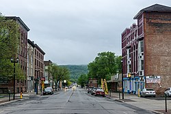
Herkimer
Herkimer, New York | |
|---|---|
Town | |
 North Main Street | |
 Location of Herkimer within Herkimer County | |
| Coordinates: 43°1′34″N 74°59′25″W / 43.02611°N 74.99028°W | |
| Country | United States |
| State | New York |
| County | Herkimer |
| Government | |
| • Mayor | Dominic J. Frank (R)
Town Council
|
| Area | |
| • Total | 32.23 sq mi (83.47 km2) |
| • Land | 31.66 sq mi (82.00 km2) |
| • Water | 0.57 sq mi (1.47 km2) |
| Population (2010) | |
| • Total | 10,175 |
| • Estimate (2016)[2] | 9,822 |
| • Density | 310.21/sq mi (119.78/km2) |
| Time zone | EST |
| • Summer (DST) | EDT |
| ZIP code | 13350 |
| Area code | 315 |
| FIPS code | 36-043-34132 |
| Website | townofherkimer |
Herkimer ni nkhalwe (county) iyo ikusangika mu nthavwa(state) ya New York, charu cha United States,nthunthu la Amerika Wakumpoto.
Ukaboni
- ↑ "2016 U.S. Gazetteer Files". United States Census Bureau. Retrieved July 5, 2017.
- ↑ Cite warning:
<ref>tag with nameUSCensusEst2016cannot be previewed because it is defined outside the current section or not defined at all.
Albany • Allegany • Bronx • Broome • Cattaraugus • Cayuga • Chautauqua • Chemung • Chenango • Clinton • Columbia • Cortland • Delaware • Dutchess • Erie • Essex • Franklin • Fulton • Genesee • Greene • Hamilton • Herkimer • Jefferson • Kings(Brooklyn) • Lewis • Livingston • Madison • Monroe • Montgomery • Nassau • New York (Manhattan) • Niagara • Oneida • Onondaga • Ontario • Orange • Orleans • Oswego • Otsego • Putnam • Queens • Rensselaer • Richmond (Staten Island) • Rockland • Saint Lawrence • Saratoga • Schenectady • Schoharie • Schuyler • Seneca • Steuben • Suffolk • Sullivan • Tioga • Tompkins • Ulster • Warren • Washington • Wayne • Westchester • Wyoming • Yates

