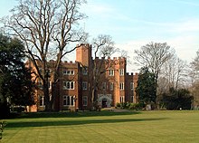
Hertford
- Tefü gebs votik vöda at, logolös padi: Hertford (Telplänov).

| |||
| |||
| Topam | |||
|---|---|---|---|
| Län: | Regän Pebalöl | ||
| Tat: | Linglän | ||
| Koordinats: | 51°47'42"N, 0°4'41"W | ||
| Nüns cifik | |||
| Nem calöfik: | Hertford | ||
| Fün: | 912 | ||
| Belödans: | 29,299, 26,658, 24,720, 29,418 | ||
| Sürfat: | 6.370 kvadamilmet | ||
| Timatopäd: | UTC±00:00[*], Europe/London[*], UTC+01:00[*] | ||
| Potakot: | SG14, SG13 | ||
| Foyümot telefonik: | 01992 | ||
| Resodatoped: | https://www.hertford.gov.uk | ||
   | |||
Hertford (pron: ['hɑtֽfəd] u ['hɑֽfəd]; in Hertford it, ['(h)ɑːʔֽfəd]) binon cifazif grafäna: Hertfordshire, in Linglän.
Hertford labon belödanis 24 180 (2001).
|
Abbots Langley | Berkhamsted | Bishop's Stortford | Borehamwood | Broxbourne | Bushey | Cheshunt | Croxley Green | Harpenden | Hatfield | Hemel Hempstead | Hertford | Hitchin | Hoddesdon | Letchworth Garden City | Potters Bar | Rickmansworth | Royston | South Oxhey | Stevenage | St Albans | Tring | Ware | Watford | Welwyn | Welwyn Garden City | |
