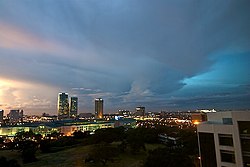
Muntinlupa
Muntinlupa | |
|---|---|
Ciudad altamente urbanizada | |
 | |
 Mapa de Gran Manila con Muntinlupa resaltado | |
| Coordenadas: 14°23'N, 121°3'E | |
| Nación | Filipinas |
| Región | Gran Manila |
| Provincia | Gran Manila |
| Número de barangay | 9 |
| Gobierno | |
| • Type | ayuntamiento |
| • Electorado | Error en la secuencia de órdenes: la función «getValue» no existe. votantes (9 Mayo 2022) |
| Superficie | |
| • Total | 39,75 km2 (15,35 sq mi) |
| Elevation | 26 m (85 ft) |
| Populación (1 Mayo 2020) | |
| • Total | 543,445 |
| • Densidad | 14/km2 (35/sq mi) |
| • Hogares | 138,331 |
| Economía | |
| • Clase de ingresos | el primera clase clase de ciudad |
| • Incidencia de la pobreza | Error en la secuencia de órdenes: la función «getValue» no existe.% (Error: fecha y hora no válidas.)[2] |
| • Ingresos | ₱ <strong4a4df3e5">Error (Error: fecha y hora no válidas.) |
| • Activos | ₱ <strong4a4df3e5">Error (Error: fecha y hora no válidas.) |
| • Pasivos | ₱ <strong4a4df3e5">Error (Error: fecha y hora no válidas.) |
| • Gastos | ₱ <strong4a4df3e5">Error (Error: fecha y hora no válidas.) |
| Huso horario | UTC+8 (PST) |
| Código postal | 1770–1777, 1780, 1799 |
| PSGC | |
| Código telefonico | 02 |
| Lenguaje nativo | Tagalog |
| Website | http://www.muntinlupacity.gov.ph/ |
Muntinlupa el primera clase clase de ciudad na provincia de Gran Manila, Filipinas. Tiene este zona de 39.75 kilometro cuadrado.
Comporme del 1 Mayo 2020 censo este tiene papulidad de 543,445 personas y 138,331 hogares. El designada codigo postal 1770–1777 y PSGC 1380800000.
Barangay
- Alabang
- Bayanan
- Buli
- Cupang
- New Alabang Village
- Poblacion
- Putatan
- Sucat
- Tunasan
Demografía
| Año | Populación | ±% p.a. |
|---|---|---|
| 1903 | 3128 | — |
| 1918 | 4712 | +2.77% |
| 1939 | 9288 | +3.28% |
| 1948 | 18 444 | +7.92% |
| 1960 | 21 893 | +1.44% |
| 1970 | 65 057 | +11.49% |
| 1975 | 94 563 | +7.79% |
| 1980 | 136 679 | +7.64% |
| 1990 | 278 411 | +7.38% |
| 1995 | 399 846 | +7.02% |
| 2000 | 379 310 | −1.12% |
| 2007 | 452 943 | +2.48% |
| 2010 | 459 941 | +0.56% |
| 2015 | 504 509 | +1.78% |
| 2020 | 543 445 | +1.47% |
| Ref: Autoridad de Estadísticas de Filipinas[3][4][5][6] | ||
Referencias
- ↑ «Province:». PSGC Interactive. Quezon City, Philippines: Philippine Statistics Authority. Consultado el Diciembre 17, 2016.
- ↑ https://psa.gov.ph/sites/default/files/Table%202a.%20Updated%20Annual%20Per%20Capita%20Poverty%20Threshold%2C%20Poverty%20Incidence%20and%20Magnitude%20of%20Poor%20Population%20with%20Measures%20of%20Precision%2C%20%20by%20Region%2C%20Province%20and%20HUC_2018.xlsx.
- ↑ Census of Population (2015). "National Capital Region (NCR)". Total Population by Province, City, Municipality and Barangay. Philippine Statistics Authority.
- ↑ Census of Population and Housing (2010). "National Capital Region (NCR)". Total Population by Province, City, Municipality and Barangay. NSO.
- ↑ Censuses of Population (1903–2007). "National Capital Region (NCR)". Table 1. Population Enumerated in Various Censuses by Province/Highly Urbanized City: 1903 to 2007. NSO.
- ↑ «Province of». Municipality Population Data. Local Water Utilities Administration Research Division. Consultado el Diciembre 17, 2016.
Enlaces externos
- PhilAtlas.com
- Philippine Standard Geographic Code
- Local Governance Performance Management System
- www
.muntinlupacity .gov .ph
| Manila | |
| Ciudad: | Caloocan ▪ Las Piñas ▪ Makati ▪ Malabon ▪ Mandaluyong ▪ Manila ▪ Marikina ▪ Muntinlupa ▪ Navotas ▪ Parañaque ▪ Pasay ▪ Pásig ▪ Ciudad Quezon ▪ San Juan ▪ Taguig ▪ Valenzuela |
| Municipalidad: | Pateros |
