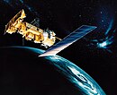
ESSA-3
 | |
| Names | TOS-A |
|---|---|
| Mission type | Weather satellite |
| Operator | ESSA/NASA |
| COSPAR ID | 1966-087A |
| SATCAT no. | 2435 |
| Spacecraft properties | |
| Manufacturer | RCA Astro |
| Launch mass | 145 kilograms (320 lb)[1] |
| Start of mission | |
| Launch date | October 2, 1966, 10:34 UTC[2] |
| Rocket | Delta C |
| Launch site | Vandenberg LC-2E |
| End of mission | |
| Disposal | Decommissioned |
| Deactivated | December 2, 1968 |
| Orbital parameters | |
| Reference system | Geocentric |
| Regime | Low Earth |
| Eccentricity | 0.00703 |
| Perigee altitude | 1,383 kilometers (859 mi) |
| Apogee altitude | 1,493 kilometers (928 mi) |
| Inclination | 100.9° |
| Period | 114.6 minutes |
| Epoch | October 2, 1966 |
TOS | |
ESSA 3 (or TOS-A) was a spin-stabilized operational meteorological satellite.[3] Its name was derived from that of its oversight agency, the Environmental Science Services Administration (ESSA).
Operation

The satellite's skeleton was made of aluminum and stainless steel and had the shape of a prism with an eighteen-sided base.
Power was supplied by 12,000 1x2 cm photovoltaic cells arranged on its sides, which were used to charge 21 NiCd batteries.
Stabilization in orbit was provided by rotational movement at a speed of 9.2 revolutions per minute, maintained by a magnetic attitude control system (MASC, Magnetic Attitude Spin Coil). Its actuator was a coil, and the torque necessary for position control was generated by the interaction of the Earth's magnetic field with the magnetic field induced in the satellite. An additional stabilization system was provided by five constant-current engines mounted on the circumference of its bottom.[3]
A single monopole antenna placed at top was used for communication with Earth. Two dipole antennas (4 rods protruding from the bottom) were used to transmit telemetry.
Cameras were triggered automatically when Earth entered the field of view. The pictures were transmitted directly to Earth or recorded onboard. The satellite was equipped with two twin independent wide-angle Vidicon television cameras. These could work simultaneously or alternately.
The satellite was also equipped with a Flat Plane Radiometer (FPR) used to measure solar energy reflected from the Earth.[4]
Mission


ESSA-3 was launched on October 2, 1966, at 10:34 UTC. It was launched atop a Delta rocket from Vandenberg Air Force Base, California.[5][6] The spacecraft had a mass of 132 kilograms (291 lb) at the time of launch. ESSA-3 had an inclination of 100.9°, and an orbited the Earth once every 114 minutes. Its perigee was 1,383 kilometers (859 mi) and its apogee was 1,493 kilometers (928 mi).[7]
One of the first images taken by ESSA 3 was of Category 4 Hurricane Inez over the Bahamas and Florida.
The satellite operated without failures until January 20, 1967, when its FPR radiometer stopped working. On September 29, 1967, one of the cameras stopped working. On October 9, 1968, the second camera failed. The satellite was decommissioned on December 2, 1968.[3]
References
- ^ "ESSA 3". National Space Science Data Center. Retrieved June 4, 2018.
- ^ McDowell, Jonathan. "Launch Log". Jonathan's Space Page. Retrieved June 4, 2018.
- ^ a b c "ESSA 3". NSSDCA.
- ^ "TIROS 9 / ESSA 1, ..., 9 (Operational TIROS)". Gunter's Space Page. Retrieved November 5, 2024.
- ^ "Launch/Orbital information for ESSA 3". NSSDCA.
- ^ McDowell, Jonathan. "launchlog". Jonathan's Space Report.
- ^ "Technical details for satellite ESSA 3 (TOS-A)". N2YO.com - Real Time Satellite Tracking and Predictions. Retrieved November 5, 2024.
![]() This article incorporates public domain material from ESSA 3. National Aeronautics and Space Administration. Retrieved June 4, 2018.
This article incorporates public domain material from ESSA 3. National Aeronautics and Space Administration. Retrieved June 4, 2018.
