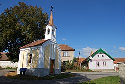
Lom (Strakonice District)
Lom | |
|---|---|
 Chapel | |
 Flag  Coat of arms | |
 Lom Location in the Czech Republic | |
| Coordinates: 49°24′38″N 13°59′20″E / 49.41056°N 13.98889°E | |
| Country | |
| Region | South Bohemian |
| District | Strakonice |
| First mentioned | 1299 |
| Area | |
| • Total | 5.70 km2 (2.20 sq mi) |
| Elevation | 474 m (1,555 ft) |
| Population (2023-01-01)[1] | |
| • Total | 119 |
| • Density | 21/km2 (54/sq mi) |
| Time zone | UTC+1 (CET) |
| • Summer (DST) | UTC+2 (CEST) |
| Postal code | 388 01 |
| Website | www |
Lom is a municipality and village in Strakonice District in the South Bohemian Region of the Czech Republic. It has about 100 inhabitants.
Lom lies approximately 18 kilometres (11 mi) north of Strakonice, 61 km (38 mi) north-west of České Budějovice, and 82 km (51 mi) south-west of Prague.
Administrative parts
The village of Míreč is an administrative part of Lom.
References
Wikimedia Commons has media related to Lom (Strakonice District).
| Authority control databases: National |
|---|