Shahr-e Babak
Shahr-e Babak
Persian: شهربابك | |
|---|---|
City | |
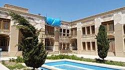 Mosakhani Building | |
 Shahr-e Babak | |
| Coordinates: 30°07′24″N 55°07′02″E / 30.12333°N 55.11722°E[1] | |
| Country | Iran |
| Province | Kerman |
| County | Shahr-e Babak |
| District | Central |
| Population (2016)[2] | |
| • Total | 51,620 |
| Time zone | UTC+3:30 (IRST) |
Shahr-e Babak (Persian: شهربابك, also romanized as Shahr-e Bābak, Shahr-i-Bābak, and Shahr Bābak)[3] is a city in the Central District of Shahr-e Babak County, Kerman province, Iran, and serves as both capital of the county and of the district.
At the 2006 National Census, its population was 43,916 in 10,401 households.[4] The following census in 2011 counted 45,256 people in 11,928 households.[5] The latest census in 2016 showed a population of 51,620 people in 15,375 households.[2]
Situation
Shahr-e Babak is an ancient city in Iran. Historians believe this town was built by Ardeshir Babakan, the most famous Sasanian king, nearly 1,800 years ago. Meymand, one of the 4 oldest villages in Iran, is 36 km far from Shahr-e Babak. Sarcheshmeh and Miedook, the biggest copper mines in Iran, are located around this town.
Shahr-e Babak is located in the west part of the Kerman province, Iran. To its east is Rafsanjan, in its southern limits is Sirjan, and to the north and west has common borders with the province of Yazd. The city is one of the ancient cities of Iran, and its founder is said to be Babak (the father of Ardeshir Babakan). Such that ancient geographers have mentioned this city in their records, and others have related its historical past with that of Kerman.
Shahr-e Babak was ruled by Nizari Ismailis about 200 years ago. It is known as the "Land of Copper." The county has many villages namely, Eshkoor, Barfeh, Hesarooyeh, Sohrab, Estabraq, Riseh, Pah Qaleh, etc.

Ayyoub's (Job's) Cave is located near Dehaj.
References
- ^ OpenStreetMap contributors (10 July 2023). "Shahr-e Babak, Shahr-e Babak County" (Map). OpenStreetMap. Retrieved 10 July 2023.
- ^ a b "Census of the Islamic Republic of Iran, 1395 (2016)". AMAR (in Persian). The Statistical Center of Iran. p. 08. Archived from the original (Excel) on 20 October 2020. Retrieved 19 December 2022.
- ^ Shahr-e Babak can be found at GEOnet Names Server, at this link, by opening the Advanced Search box, entering "-3084162" in the "Unique Feature Id" form, and clicking on "Search Database".
- ^ "Census of the Islamic Republic of Iran, 1385 (2006)". AMAR (in Persian). The Statistical Center of Iran. p. 08. Archived from the original (Excel) on 20 September 2011. Retrieved 25 September 2022.
- ^ "Census of the Islamic Republic of Iran, 1390 (2011)" (Excel). Iran Data Portal (in Persian). The Statistical Center of Iran. p. 08. Retrieved 19 December 2022.
| International | |
|---|---|
| National | |
Kerman province, Iran | ||
|---|---|---|
| Capital |  | |
| Counties and cities | ||
| Sights |
| |
| Places | ||