Chukchi Sea
| Chukchi Samundar | |
|---|---|
 | |
| Jagha | North Asia aur Northern America |
| Coordinates | 69°N 172°W / 69°N 172°W |
| Rakam | Samundar |
| Basin ke des | Russia aur United States |
| Surface area | 620,000 km2 (240,000 sq mi) |
| Average gahiraai | 80 m (260 ft) |
| Water volume | 50,000 km3 (4.1×10¹⁰ acre⋅ft) |
| References | [1][2][3] |
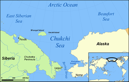
Chukchi Samundar, jiske Chuuk Samundar, Chukotsk Samundar[4] aur Chukotsk ke samundar[5] ke naam se bhi jaana jaae hae, Arctic Ocean ke ek samundar hae. Iske west me Long Strait, east me Point Barrow, Alaska aur south me Bering Sea hae. Ii samundar pe ek khaas port Uelen hae jon Russia me hae. International Date Line Chukchi Sea ke northwest se souteast me cross kare hae. Ii samundar ke area 595,000 square kilometres (230,000 square miles) hae aur isme saal ke chaar mahina me samundar chale sake hae. Ii samundar ke naam Chukchi log se aais hae jon Chukolta Peninsula ke shores me rahe hae.
Siimaa (Boundary)
International Hydrographic Organization, "Chuckchi Samundar" ke siimaa ke ii rakam se define kare hae:[6]
West me East Siberian Samundar ke eastern siimaa, Wrangel Island ke Northernmost point se Blossom Point aur fir mainland pe Cape Yakan (176°40′E)].
North me Ek line Point Barrow, Alaska (71°20′N 156°20′W / 71.333°N 156.333°W) se Wrangel Island (179°30'W) ke northernmost point.
South me Arctic Circle [66°33′46″N] Siberia aur Alaska ke biich me. Bering Sea ke northernmost point
Jaada kar ke log ii biswas kare hae ki southern boundry aur south me hae, jahan pe Bering Strait sab sepatraa hae jon 66th parallel north pe hae.
References
- ↑ R. Stein, Arctic Ocean Sediments: Processes, Proxies, and Paleoenvironment, p. 37
- ↑ Beaufort Sea, Great Soviet Encyclopedia (in Russian)
- ↑ Beaufort Sea, Encyclopædia Britannica on-line
- ↑ "education.rec.org Seas and Oceans: The Chukotsk Sea". Archived from the original on 2021-10-17. Retrieved 2019-04-11.
- ↑ Owen, Richard. "Race against time to save ice-bound ships", 15 October 1983.
- ↑ "Limits of Oceans and Seas, 3rd edition" (PDF). International Hydrographic Organization. 1953. Archived from the original (PDF) on 8 October 2011. Retrieved 28 December 2020.