ਬੇਰਿੰਗ ਪਣਜੋੜ
ਗੁਣਕ : 66°0′N 169°0′W / 66.000°N 169.000°W / 66.000; -169.000
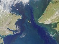
ਬੇਰਿੰਗ ਪਣਜੋੜ ਦੀ ਉਪਗ੍ਰਿਹੀ ਤਸਵੀਰ ਇੱਕ US-ਅਧਾਰਤ ਕੈਮਰਾ Archived 2009-07-26 at the Wayback Machine. ਜੋ ਬੇਰਿੰਗ ਪਣਜੋੜ ਦੇ ਦੁਆਲੇ ਦੇ ਦ੍ਰਿਸ਼ ਵਿਖਾਉਂਦਾ ਹੈਬੇਰਿੰਗ ਪਣਜੋੜ ਦਾ ਸਮੁੰਦਰੀ ਚਾਰਟ ਬੇਰਿੰਗ ਪਣਜੋੜ (ਰੂਸੀ : Берингов пролив , ਬੇਰਿੰਗੋਵ ਪ੍ਰੋਲਿਵ , ਯੂਪਿਕ: Imakpik [1] [2] ਏਸ਼ੀਆਈ ਮਹਾਂਦੀਪ ਦੇ ਸਭ ਤੋਂ ਪੂਰਬੀ ਬਿੰਦੂ ਦੇਜ਼ਨੇਵ ਅੰਤਰੀਪ, ਚੁਕਚੀ ਪਰਾਇਦੀਪ, ਰੂਸ ਤੋਂ ਲੈ ਕੇ ਉੱਤਰੀ ਅਮਰੀਕੀ ਮਹਾਂਦੀਪ ਦੇ ਸਭ ਤੋਂ ਪੱਛਮੀ ਬਿੰਦੂ ਪ੍ਰਿੰਸ ਆਫ਼ ਵੇਲਜ਼ ਅੰਤਰੀਪ, ਅਲਾਸਕਾ , ਸੰਯੁਕਤ ਰਾਜ ਤੱਕ ਫੈਲਿਆ ਹੋਇਆ ਹੈ।
ਹਵਾਲੇ
↑ Forbes, Jack D. 2007. The American Discovery of Europe . Urbana: University of Illinois Press, pp. 84 ff., 198.
↑ Stuckey, M., & J. Murphy. 2001. By Any Other Name: Rhetorical Colonialism in North America. American Indian Culture, Research Journal 25(4): 73–98, p. 80.
The article is a derivative under the Creative Commons Attribution-ShareAlike License .
A link to the original article can be found here and attribution parties here
By using this site, you agree to the Terms of Use . Gpedia ® is a registered trademark of the Cyberajah Pty Ltd