Gegharkunik Province
Gegharkunik Գեղարքունիք | |
|---|---|
 Location o Gegharkunik athin Armenie | |
| Coordinates: 40°25′N 45°12′E / 40.417°N 45.200°E | |
| Kintra | Armenie |
| Caipital | Gavar |
| Govrenment | |
| • Govrenor | Nver Poghosian |
| Area | |
| • Total | 5348 km2 (2,065 sq mi) |
| Area rank | 1st |
| Population (2002) | |
| • Total | 215,371 |
| • Rank | 7t |
| • Density | 40/km2 (100/sq mi) |
| Time zone | UTC+04 |
| • Summer (DST) | UTC+05 |
| Postal code | 1201–1626 |
| ISO 3166 code | AM.GR |
| FIPS 10-4 | AM04 |
| Website | gegharkunik.gov.am |
Gegharkunik (Armenie: Գեղարքունիք) is a province (marz) o Armenie. Gegharkunik wis namit efter Gegham. Gegham wis a Haykazuni King an fift generation efter Hayk. Gegham wis the faither o Sisak o Syunid nobles an Arma the grandfaither o Ara the Bonnie. Geghama muntains an Geghama lake, presently Lake Sevan, wur namit efter Gegham.
Gegharkunik Province is in the east o Armenie, borderin Azerbaijan. At 5,348 km², Gegharkunik is the lairgest province in Armenie bi aurie. Housomeivver, thareby 1,278 km² o its territory is covered bi Lake Sevan, the lairgest loch in the Caucasus an a major tourist attraction o the region. It haes a exclave athin Azerbaijan, Artsvashen, whilk came unner Azerbaijani control in the Nagorno-Karabakh War. Its caipital is Gavar.
Specially protectit auries
Sevan National Park
Sevan Naitional Pairk wis established in 1978 tae pertect Lake Sevan. It occupees the territories o the Lake Sevan comprisin the bed o intermontane concavity o Sevan an those freed frae its bed. The aurie comprises 1501 square kilometers, o whilk 24.9 thoosan hectares are lakeside land. It is surroondit wi the slopes o muntain chains o Areguni, Geghama, Vardenis, Pambak an Sevan. Some 1600 plant an 330 ainimal species are foond here. The pairk is dividit intae 3 zones: a reserve, a recreation zone, an a zone for economic uise.
Akhnabad Yew Grove State Reservation
Akhnabad Yew Grove State Reservation wis established in 1958. It is locatit on Mt. Tsaghkot o the Miapor muntain range near Aghavnavank. The main species o the reservation is yew (taxus baccata L.). On the territory o the reservation yew grows in the mixed wid (beech, aik, maple etc.). Trees 300–400 year auld, 25 m heich an wi 70–90 cm trunk diameter can be foond thare.
Getik State Reservation
Getik State Reservation wis established in 1971. Main protectit objects are forest fauna.
Juniper Forest State Reservation
Juniper Forest State Reservation wis established in 1958. Main pertected object is relict aiten, as weel as ither numerous species.
Commonties
The province o Gegharkunik consists o the follaein 92 commonties (hamaynkner), o whilk 5 (bauld in the table) are considered urban an 87 are considered rural.[1] The diveesion belaw is bi raion, the admeenistrative subdiveesions o Armenie afore 1995. Thare settlements lik Chichakli an aw.
| Gavar | Sevan | Chambarak | Martuni | Vardenis |
|---|---|---|---|---|
|
Gallery
- Gegharkunik
-
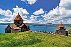 Sevanavank, 874 AD
 -
 Hayravank, 9t century
 -
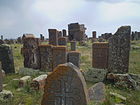 Noraduz cemetery, 10t century
 -
 Sevan peninsulae
 -
 Ttujur veelage


References
- Report of the results of the 2001 Armenian Census, Naitional Statistical Service o the Republic o Armenie
- ↑ "RA Gegharkunik Marz" (PDF). Marzes of the Republic of Armenia in Figures, 2002–2006. National Statistical Service of the Republic of Armenia. 2007.
Freemit airtins
- Gegharkunik Marz Tourist Guide
- Gegharkunik destrict Archived 2010-08-22 at the Wayback Machine
Caipital: Gavar | ||
| Gavar |  | |
| Sevan | ||
| Chambarak | ||
| Martuni | ||
| Vardenis |
| |
| Marzer (մարզեր) | ||
|---|---|---|
| Ceety wi special status |
| |