අක්ෂාංශ

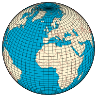
අක්ෂාංශ යනු පෘථිවිය මතුපිට ලක්ෂයක කොණික දුරයි. ධ්රැවය කේන්ද්ර කොට ගත් ගෝලයක් තුළ විහිදෙන කල්පිත ඒක කේන්ද්රීය වෘත්ත වේ. නමුත් පෘථිවිය පරිපුර්ණ ගෝලයක් නොවන නිසා මෙම අක්ෂාංශයන් නිවැරදි නොවන බව නුතන විදුවතුන්ගේ අදහසයි. පුරාණ ග්රීකයන් විසින් මෙය සංකල්පයක් ලෙස පෘථිවිය විස්තර කිරීමට මුලින්ම යොදා ගන්නා ලදි. නිරක්ෂය හෙවත් මහා ගෝලය ඒනම් සමකය, අක්ෂාංශ අංශක 0 විසින් පෘථිවිය අර්ධගෝල දෙකකට බෙදනු ලැබේ. සමකය නම් කල්පිත රේඛාව විශාලතම අක්ෂාංශයයි. ධ්රැවය යනු උතුරු හා දකුණු අක්ෂාංශ අංශක 90 වේ. පෘථිවියේ පිහිටීම විස්තර කිරීමට නුතනයේත් මෙය දේශාංෂ සමඟ භාවිතා කරයි. උදාහරණ : ශ්රී ලංකාවේ පිහිටිම උතුරු අක්ෂාංශ අංශක 5’ ත් 10’ ත් අතරය.
පෘථිවිය උතුරු හා දකුණු අර්ධගෝල ලෙස 2කට බෙදෙන කල්පිත වෘත්තය අක්ෂාංශ අංශක බිංදුව 0ං හෙවත් සමකය ලෙස හැඳින්වේ
ආශ්රිත ලිපි
- Altitude (mean sea level)
- Bowditch's American Practical Navigator
- Cardinal direction
- Circle of latitude
- Colatitude
- Declination on celestial sphere
- Degree Confluence Project
- Geodesy
- Geodetic datum
- Geographic coordinate system
- Geographical distance
- Geomagnetic latitude
- Geotagging
- Great-circle distance
- History of latitude
- Horse latitudes
- International Latitude Service
- List of countries by latitude
- Longitude
- Natural Area Code
- Navigation
- Orders of magnitude (length)
- World Geodetic System
මූලාශ්ර
පාද සටහන්
උපහරණ
භාහිර සබැඳි
අක්ෂාංශ ගැන තවත් දේ විකිපිඩියා සහෝදර ව්යාපෘති හරහා සොයාගන්න
| |
| වික්ෂනරිය වෙතින් අර්ථ දැක්වීම් | |
| කොමන්ස් වෙතින් ඡායාරූප හා මාධ්ය | |
| විකිසරසවිය වෙතින් ඉගෙනුම් මූලාශ්ර | |
| විකිපුවත් වෙතින් පුවත් කථාංග | |
| විකිකියමන් වෙතින් උපුටා දැක්වීම් | |
| විකිප්රභව වෙතින් ප්රභව පෙළ | |
| විකිපොත් වෙතින් පෙළපොත් | |
- GEONets Names Server සංරක්ෂණය කළ පිටපත 2008-03-09 at the Wayback Machine, access to the National Geospatial-Intelligence Agency's (NGA) database of foreign geographic feature names.
- Resources for determining your latitude and longitude සංරක්ෂණය කළ පිටපත 2008-05-19 at the Wayback Machine
- Convert decimal degrees into degrees, minutes, seconds
- Distance calculation based on latitude and longitude - JavaScript version
- 16th Century Latitude Survey
- Determination of Latitude by Francis Drake on the Coast of California in 1579
