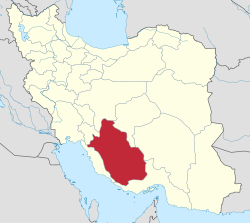
จังหวัดฟอร์ส
จังหวัดฟอร์ส استان فارس | |
|---|---|
|
ตามเข็มนาฬิกาจากบน: สุสานพระเจ้าไซรัสมหาราชที่ ปาซาร์กาด, เนินปราสาทกะรีม ข่านที่ชีรอซ, ทุ่งคาโนลาที่อะลามะรูชดัชต์, หุบเขาบีชอปูร์, แน็กเชโรสแต็ม และซากเมืองทาชาราในเปอร์เซเปอลิส | |
 ที่ตั้งในประเทศอิหร่าน | |
| พิกัด: 29°37′N 52°32′E / 29.617°N 52.533°E | |
| ประเทศ | |
| แคว้น | แคว้น 2 |
| เมืองหลวง | ชีรอซ |
| เทศมณฑล | 36 |
| พื้นที่ | |
| • ทั้งหมด | 122,608 ตร.กม. (47,339 ตร.ไมล์) |
| ประชากร (2016)[2] | |
| • ทั้งหมด | 4,851,274 คน |
| • ประมาณ (2020) | 5,051,000[1] คน |
| • ความหนาแน่น | 40 คน/ตร.กม. (100 คน/ตร.ไมล์) |
| เขตเวลา | UTC+03:30 (เวลามาตรฐานอิหร่าน) |
| • ฤดูร้อน (เวลาออมแสง) | UTC+04:30 (เวลามาตรฐานอิหร่าน) |
| รหัสพื้นที่ | 071 |
| ภาษาหลัก | เปอร์เซีย ควาซไคว ลูรี[3][4] สำเนียงฟอร์ส |
| ปี | ประชากร | ±% |
|---|---|---|
| 2006 | 4,336,878 | — |
| 2011 | 4,596,658 | +6.0% |
| 2016 | 4,851,274 | +5.5% |
| amar.org.ir | ||
ฟอร์ส (เปอร์เซีย: فارس, ออกเสียง: [ˈfɒː(ɾ)s]) ซึ่งยังเป็นที่รู้จักกันในชื่อ ปาร์ส (پارس), เปร์ซิส, เปอร์เซีย[5] และ ฟอร์เซสถาน (فارسستان)[6][7][8][9] เป็นหนึ่งใน 31 จังหวัดของประเทศอิหร่าน ที่มีพื้นที่ 122,400 ตารางกิโลเมตร ตั้งอยู่ในภาคตะวันตกเฉียงใต้ของประเทศ ซึ่งอยู่ในแคว้น 2[10] และมีเมืองหลักอยู่ที่ชีรอซ ณ ค.ศ. 2011 ฟอร์สมีประชากร 4.6 ล้านคน โดย 67.6% อาศัยอยู่ในเมือง, 32.1% อยู่ในหมู่บ้าน และ 0.3% ไม่มีที่อยู่เป็นหลักแหล่ง (เผ่าเร่ร่อน)[11]
ฟอร์สเป็นบ้านเกิดทางประวัติศาสตร์ของชาวเปอร์เซีย[12][13] เป็นบ้านเกิดของราชวงศ์อะคีเมนิดกับซาเซเนียน ในบริเวณนี้ ยังมีซากเมืองหลวงจักรวรรดิอะคีเมนิด คือ ปาซาร์กาด และเปอร์เซเปอลิส นอกจากนี้ เนื่องด้วยความสำคัญทางประวัติศาสตร์ ทำให้ในอดีต โลกตะวันตกเคยเรียกประเทศนี้ว่า เปอร์เซีย[13][14] ก่อนที่พวกอาหรับครอบครองบริเวณนี้ แคว้นนี้เคยมีชื่อว่า ปาร์ส[15]
ศัพทมูลวิทยา
คำว่า ฟอร์ส (فارس) ในภาษาเปอร์เซีย เป็นคำที่แปลงมาจากคำว่า ปาร์ส (پارس) ซึ่งแปลงมาจากคำว่า ปอร์ซอ (𐎱𐎠𐎼𐎿) ชื่อภาษาเปอร์เซียโบราณของแคว้นเปร์ซิส คำว่า ปอร์ซอ กับ เปอร์เซีย มีต้นกำเนิดจากบริเวณนี้[16]
อ้างอิง
- ↑ Amar. "توجه: تفاوت در سرجمع به دليل گرد شدن ارقام به رقم هزار مي باشد. (in Persian)". สืบค้นเมื่อ September 29, 2020.
- ↑ "National census 2016". amar.org.ir. สืบค้นเมื่อ 2017-03-14.[]
- ↑ "پرتال سازمان ميراث فرهنگي، صنایع دستی و گردشگري > استانها > فارس > آداب و رسوم". 11 January 2012. คลังข้อมูลเก่าเก็บจากแหล่งเดิมเมื่อ 11 January 2012.
- ↑ "สำเนาที่เก็บถาวร". คลังข้อมูลเก่าเก็บจากแหล่งเดิมเมื่อ 2012-10-11. สืบค้นเมื่อ 2021-03-13.
- ↑ Sykes, Percy (1921). A History of Persia. London: Macmillan and Company. p. 43.
- ↑ https://www.britannica.com/place/Fars
- ↑ https://www.google.no/books/edition/The_History_of_the_World_Comprising_a_Ge/ekoFAAAAYAAJ?hl=no&gbpv=1&dq=farsistan&pg=PA348&printsec=frontcover
- ↑ https://www.google.no/books/edition/Lectures_on_ancient_history_from_the_ear/UmIBAAAAQAAJ?hl=no&gbpv=1&dq=farsistan&pg=PA94&printsec=frontcover
- ↑ https://www.google.no/books/edition/Universal_geography_or_A_description_of/z2QDAAAAQAAJ?hl=no&gbpv=1&dq=farsistan&pg=PA307&printsec=frontcover
- ↑ "استانهای کشور به ۵ منطقه تقسیم شدند" [The Provinces of the Country Were Divided Into 5 Regions]. Hamshahri Online (ภาษาเปอร์เซีย). 22 June 2014. เก็บจากแหล่งเดิมเมื่อ 23 June 2014.
- ↑ "National Population and Housing Census, 2011".
- ↑ Austin, Peter (1 January 2008). One Thousand Languages: Living, Endangered, and Lost. University of California Press. ISBN 9780520255609 – โดยทาง Google Books.
- ↑ 13.0 13.1 Xavier de Planhol (24 January 2012). "FĀRS i. Geography". Encyclopædia Iranica. Vol. IX. pp. ?–336.
The name of Fārs is undoubtedly attested in Assyrian sources since the third millennium B.C.E. under the form Parahše. Originally, it was the "land of horses" of the Sumerians (Herzfeld, pp. 181-82, 184-86). The name was adopted by Iranian tribes which established themselves there in the 9th century B.C.E. in the west and southwest of Urmia lake. The Parsua (Pārsa) are mentioned there for the first time in 843 B.C.E., during the reign of Salmanassar III, and then, after they migrated to the southeast (Boehmer, pp. 193-97), the name was transferred, between 690 and 640, to a region previously called Anšan (q.v.) in Elamite sources (Herzfeld, pp. 169-71, 178-79, 186). From that moment the name acquired the connotation of an ethnic region, the land of the Persians, and the Persians soon thereafter founded the vast Achaemenid empire. A never-ending confusion thus set in between a narrow, limited, geographical usage of the term—Persia in the sense of the land where the aforesaid Persian tribes had shaped the core of their power—and a broader, more general usage of the term to designate the much larger area affected by the political and cultural radiance of the Achaemenids. The confusion between the two senses of the word was continuous, fueled by the Greeks who used the name Persai to designate the entire empire. It lasted through the centuries of Arab domination, as Fārs, the term used by Muslims, was merely the Arabicized version of the initial name.
- ↑ M. A. Dandamaev (1989). A Political History of the Achaemenid Empire. BRILL. pp. 4–6. ISBN 9004091726.
- ↑ Zargaran, Arman. "The City of Shiraz and Fars Province, the root of medical sciences in the history." (2012): 103-104.
- ↑ Zangiabadi, A., and M. Akbari. "Assessment and Analysis of Development Indicator in Township of Fars Province." (2011): 113-122.
บรรณานุกรม
- W. Barthold (1984). "Fars". An Historical Geography of Iran. Translated by Svat Soucek. Princeton University Press. pp. 148–168. ISBN 978-1-4008-5322-9.
แหล่งข้อมูลอื่น
- Province of Fars on Iran Chamber Society
- Houchang E. Chehabi (บ.ก.). "Regional Studies: Fars". Bibliographia Iranica. USA: Iranian Studies Group at MIT. คลังข้อมูลเก่าเก็บจากแหล่งเดิมเมื่อ 2021-11-02. สืบค้นเมื่อ 2021-03-13. (Bibliography)
- Fars Tourist Attractions


