Kitakyushu
Kitakyushu 北九州 | |
|---|---|
Designatit ceety | |
| 北九州市 · Ceety o Kitakyushu[1] | |
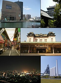
 Clockwise frae Tap, River-walk Kitakyushu, Kokura Castle, Mojiko railroad Station, umwhile steid o Higashida blast fumace, Nicht in Kokura Toun, view frae Mount Adachi, Tanga Mercat in Kokura | |
 Location of Kitakyushu in Fukuoka | |
| Coordinates: 33°53′N 130°53′E / 33.883°N 130.883°ECoordinates: 33°53′N 130°53′E / 33.883°N 130.883°E | |
| Kintra | Japan |
| Region | Kyushu |
| Prefectur | Fukuoka |
| Govrenment | |
| • Mayor | Kenji Kitahashi |
| Area | |
| • Total | 486.81 km2 (187.96 sq mi) |
| Population (Januar 1, 2010) | |
| • Total | 983,037 |
| • Density | 2019.34/km2 (5,230.1/sq mi) |
| Symbols | |
| • Tree | Ichiigashi (Japanese beech) |
| • Flouer | Tsutsuji (Azalea) Himawari (Sunflouer) |
| Time zone | UTC+9 (Japan Staundart Time) |
| City Hall Address | 1-1 Jōnai, Kokura Kita-ku, Kitakyushu-shi, Fukuoka-ken 803-8501 |
| Website | www |
Kitakyushu (北九州市 Kitakyūshū-shi, lit. "North Kyushu") is a ceety locatit in Fukuoka Prefectur, Kyushu, Japan.
Wards
Kitakyushu haes seiven wards (ku):
The ceety o Nakama wis tae acome the aicht ward o Kitakyushu in 2005 (tae be cried Nakama-ku). Houever, the planned merger wis rejectit on December 24, 2004 bi Nakama's ceety cooncil, despite havin been initiated bi Nakama ceety.
History
Kokura Prefectur
Kokura Prefectur wis foondit separately frae Fukuoka Prefectur in 1871 when the clan seestem wis abolished. The auld widen-biggit Kokura Prefectural Office is still staundin, an is bein restored. It is opposite Riverwalk Kitakyūshū. In 1876, Kokura Prefectur wis absorbed bi Fukuoka Prefectur. The ceety o Kokura wis foondit in 1900.
Warld War II
Kokura wis the primary tairget o the nuclear wappen "Fat Man" on August 9, 1945. Major Charles Sweeney haed orders tae drop the bomb visually, but aw three attempts failed due tae clouds an smoke frae Yahata, which is locatit anly 7 km wast o Kokura an haed air raids on the previous day, preventin Sweeney frae identifyin the tairget clearly. The bomb wis ultimately dropped on the ceety o Nagasaki, the seicondary tairget, at 11:02 JST.
Ceety o Kitakyushu
The ceety o Kitakyushu wis foondit on Februar 10, 1963 an wis designatit on Aprile 1, 1963 bi govrenment ordinance. The ceety wis born frae the merger o five municipalities (Moji, Kokura, Tobata, Yahata an Wakamatsu) centered aroond the auncient feudal ceety o Kokura. The ceety's seembol merk is a flouer wi the character "north" (北 kita) in the middle an five petals representin the five touns which merged.
Sister ceeties
 Dalian, Cheenae
 Incheon, Sooth Korea
 Norfolk, Virginie, Unitit States
 Tacoma, Washington, Unitit States
 Minamikyūshū, Kagoshima, Japan[2]
References
- ↑ Kitakyushu's official English name
- ↑ [広報 南九州 http://www.city.minamikyushu.lg.jp/contents/html/nanq_kouhou/201008/top.pdf#search='南九州市 Archived 2013-05-23 at the Wayback Machine 姉妹都市'] (Japanese)
Freemit airtins
- Offeecial wabsteid Archived 2003-11-30 at the Wayback Machine in Japanese (in Japanese)
- Offeecial wabsteid Archived 2009-02-11 at the Wayback Machine in Inglish (in Inglis)
- Kitakyushu page o Fukuoka Prefectur Tourism Association wabsteid Archived 2010-10-18 at the Wayback Machine (in Inglis)
- Kitakyushu Science an Research Pairk (in Inglis)
- CCA Kitakyushu Archived 2013-05-28 at the Wayback Machine (in Japanese)
