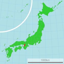
Osaka Prefectur
Osaka Prefecture 大阪府 | |
|---|---|
| Japanese transcription(s) | |
| • Japanese | 大阪府 |
| • Rōmaji | Ōsaka-fu |
 | |
| Coordinates: 34°41′11″N 135°31′12″E / 34.68639°N 135.52000°ECoordinates: 34°41′11″N 135°31′12″E / 34.68639°N 135.52000°E | |
| Kintra | Japan |
| Region | Kansai |
| Island | Honshu |
| Caipital | Osaka |
| Govrenment | |
| • Govrenor | Ichiro Matsui |
| Area | |
| • Total | 1899.28 km2 (733.32 sq mi) |
| Area rank | 46t |
| Population (1 Januar 2012) | |
| • Total | 8,864,228 |
| • Rank | 3rd |
| • Density | 4,700/km2 (12,000/sq mi) |
| ISO 3166 code | JP-27 |
| Destricts | 5 |
| Municipalities | 43 |
| Flouer | Japanese apricot (Prunus mume) Primrose (Primula sieboldii) |
| Tree | Ginkgo tree (Ginkgo biloba) |
| Bird | Bull-headed shrike (Lanius bucephalus) |
| Website | www |
Osaka Prefectur (大阪府 Ōsaka-fu) is a prefectur locatit in the Kansai region on Honshu, the main island o Japan.[1] The caipital is the ceety o Osaka. It is the centre o Osaka-Kobe-Kyoto aurie.[2]
Geography
Osaka Prefectur neighbors the prefecturs o Hyōgo an Kyoto in the north, Nara in the east an Wakayama in the sooth. The wast is open tae Osaka Bay. The Yodo an Yamato Rivers flow throu the prefectur.
Prior tae the construction o Kansai Internaitional Airport, Osaka wis the smawest prefectur in Japan. The airtificial island on which the airport wis biggit addit enough aurie tae mak it slichtly lairger than Kagawa Prefectur.[3][4]
As o 31 Mairch 2008, 10% o the tot land aurie o the prefectur wis designatit as Natural Pairks, namely Kongō-Ikoma-Kisen Quasi-Naitional Pairk, Meiji no Mori Minō Quasi-Naitional Pairk, an Hokusetsu Prefectural Natural Pairk.[5] In Julie 2011 a further aurie wis designatit for pertection as the Hannan-Misaki Prefectural Natural Pairk.[6]
Ceeties


Thirty-three ceeties are locatit in Osaka Prefectur:
|
|
|
Touns an veelages
Thir are the touns an veelages in each destrict.
|
|
|
Mergers
Notes
- ↑ Nussbaum, Louis-Frédéric. (2005). "Osaka-fu" in Japan Encyclopedia, p. 759 at Google Books; "Kansai" in p. 477 at Google Books.
- ↑ Nussbaum, "Osaka" in p. 759 at Google Books.
- ↑ "平成10年全国都道府県市区町村の面積の公表について(Official announcement on the national territory and area of 1998, by prefectures, cities, districts, towns and villages)" Archived 2003-06-11 at the Wayback Machine, Geographical Survey Institute, Government of Japan, January 29, 1999.
- ↑ "コラム Vol.017 全国都道府県市区町村面積調 (Column: "National Area Investigation" vol.017)" Archived 2007-09-28 at the Wayback Machine, Alps Mapping K.K., March 8, 2001.
- ↑ "General overview of area figures for Natural Parks by prefecture" (PDF). Ministry of the Environment. Retrieved 2 Februar 2012.
- ↑ "Hannan-Misaki Prefectural Natural Park". Ōsaka Prefecture. Archived frae the original on 16 Januar 2012. Retrieved 2 Februar 2012.
External links
- Official Osaka Prefecture homepage Archived 2012-02-17 at the Wayback Machine
- Osaka Tourism & Convention Guidance homepage Archived 2003-04-16 at the Wayback Machine

