ബാൾക്കൻ
 Geographical map of the Balkan Peninsula | |
| Geography | |
|---|---|
| Location | Southeast Europe (8–11 countries) |
| Coordinates | 42°N 22°E / 42°N 22°E |
| Area | 466,827–562,614 കി.m2 (180,243–217,226 ച മൈ) |
| Highest elevation | 2,925 m (9,596 ft) |
| Highest point | Musala (Bulgaria) |
| Administration | |
| Demographics | |
| Population | ca. 60 million (45 million only the peninsula's part) |

തെക്കു കിഴക്കൻ യൂറോപ്പിൽ മധ്യധരണ്യാഴിയിലേക്ക് തള്ളിനില്ക്കുന്ന ഉപദ്വീപാണ് ബാൾക്കൻ(balkon peninsula).[1][2][3] ബാൾക്കൻ പർവ്വതത്തിൽ നിന്നാണ് ഉപദ്വീപിന് ഈ പേര് ലഭിച്ചത്. അൽബേനിയ, ബോസ്നിയ-ഹെർസഗോവിന, ബൾഗേറിയ, ക്രൊയേഷ്യ, മൊണ്ടിനെഗ്രോ, ഗ്രീസ്, റിപ്പബ്ലിക് ഓഫ് മാസിഡോണിയ, സെർബിയ, കൊസോവൊ എന്നിവയാണ് ബാൾക്കൻ രാജ്യങ്ങൾ. തുർക്കിയുടെ ത്രേസ് ഭാഗവും ബാൾക്കനിലാണ്. റൊമാനിയ, സ്ലൊവീനിയ എന്നി രാഷ്ട്രങ്ങളേയും ബാൾക്കനിൽ ഉൾപ്പെടുത്തി കാണാറുണ്ട്. 5.5 ലക്ഷം ച.കി.മീ. ആണ് ഈ മേഖലയുടെ വിസ്തൃതി. ആറു കോടിയോളം ജനങ്ങൾ ഇവുടെ അധിവസിക്കുന്നു.

അവലംബം
- ↑ Gray, Colin S.; Sloan, Geoffrey (2014). Geopolitics, Geography and Strategy. ISBN 9781135265021. ശേഖരിച്ചത് 10 November 2014.
- ↑ "Balkans". Encyclopedia Britannica. ശേഖരിച്ചത് 2017-12-13.
- ↑ Richard T. Schaefer (2008). Encyclopedia of Race, Ethnicity, and Society. Sage. പുറം. 129. ISBN 978-1-4129-2694-2.
പുറംകണ്ണികൾ
ബാൾക്കൻവിക്കിപീഡിയയുടെ സഹോദര സംരംഭങ്ങളിൽ
 നിർവചനങ്ങൾ വിക്കിനിഘണ്ടുവിൽനിന്ന്
 മീഡിയ വിക്കിമീഡിയ കോമൺസിൽനിന്ന്
 ഉദ്ധരണികൾ വിക്കിക്വോട്ട്സിൽനിന്ന്
 ഗ്രന്ഥങ്ങൾ വിക്കിസോഴ്സിൽനിന്ന്
 Travel ഗൈഡ് വിക്കിവൊയേജിൽനിന്ന്
- Balkan Insight – Analysis from Balkans
- Balkanalysis, in-depth research on Balkan geopolitics
- Western Balkans Photo impression
- Shared Pasts in Central and Southeast Europe, 17th–21st Centuries. Eds. G. Demeter, P. Peykovska. 2015.
Balkan Peninsula countries | ||
|---|---|---|
| Geographically fully located | 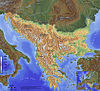 | |
| Significantly located | ||
| Mostly outside of the peninsula | ||
| See also |
| |
1 Declared independence from Serbia on 17 February 2008 and is United Nations member states, while 10 states have recognized Kosovo only to later withdraw their recognition.. | ||
Sovereign states and dependent territories of Europe | ||
|---|---|---|
| Sovereign states |
|  |
States with limitedrecognition | ||
Dependencies and other territories | ||
Earth's primary regions and subregions | |||||||
|---|---|---|---|---|---|---|---|
|
Music of Southeastern Europe (the Balkans) | |||||||
|---|---|---|---|---|---|---|---|
| By style |
| ||||||
| By country |
| ||||||
| Performers by country |
| ||||||
| Folk dances |
| ||||||
| Folk musicians |
| ||||||